
![[Religious ritual on Hispaniola].](/uploads/cache/39921-500x500.jpg)
[Religious ritual on Hispaniola].
Scarce print with a German text sheet.On certain feast-days the Indian cacique, while beating a drum, led a procession of his people to the worship of their idol, which was a strange hybrid-like creature with several heads. The men were painted black, red and yellow and came first, dressed in parrot feathers and necklaces of seashells. The women, decorated with jewellery, followed with their naked daughters. When all were assembled, the cacique inserted a stake into his throat, which made him vo...
$80
Maker : GOTTFRIED, J.L. / DE BRY.
Place : Frankfurt, M.Merian
Date : 1633
![[Cavendish reaches Morro Moreno.]](/uploads/cache/39910-500x500.jpg)
[Cavendish reaches Morro Moreno.]
Scarce print with a German text sheet showing Cavendish’s fleet anchor at a place called Morro Moreno, on the coast of Chile. The Indians came down from the high cliffs to greet the voyagers and brought with them firewood and fresh water as a sign of friendship. Later the English were taken to their homes, which were made from two sticks in the ground, with others laid across and covered with straw. The whole family, including children, lay underneath on animal skins. They were skilled fisherm...
$80
Maker : GOTTFRIED, J.L. / DE BRY.
Place : Frankfurt, M.Merian
Date : 1633

A Hysterical Map Of Death Valley National Monument -- And It's Looking Mighty Low
First edition Humorous map of Death Valley. "Drawn In Broken English by Jolly Lindgren," this comic pictorial map is full of puns and comic vignettes related to Death Valley. The Lindgren Brothers issued a number of other silly whimsical maps of national parks and other parts of the West.
$500
Maker : LINDGREN, J.
Place : Spokane, Wash., Lindgren Brothers,
Date : 1948
-500x500.jpg)
Nuovo Mondo parte Settentrionale.
Uncommon map of North America prepared by Francesco Costantino Marmocchi. Above the map "Geografia Commerciale". From "Il Globo Atlante di carte Geografiche compilate da F.C. Marmocchi per servire di corredo al suu corso di geografia commerciale", with the maps engraved by engraved by Gius. Cattaneo, Campo Antico, C. Poggiali, G. Bonatti, and Ces. Magrini.Marmocchi (Poggibonsi, 1805-Geneva, 1858) was known as a geographer and cartographer. He emigrated to Rome, and later to Corsica, later settle...
€50
Maker : MARMOCCHI, F.C.
Place : Genova, Paolo Rivara fu Giacomo
Date : 1858
![[Columbus is standing in the bow of his ship]](/uploads/cache/48524-500x500.jpg)
[Columbus is standing in the bow of his ship]
Columbus is standing in the bow of his ship, which is near the shore. He is clad in a long mantle and undercoat, while his armor lies at his feet, and his standard is floating from the foremast. Behind him is Minerva, carrying a spear and a shield with the head of Medusa in the center, presenting a laurel branch to Columbus.Behind the goddess is Mars in full armor, standing on the back of a turtle for a chariot, and drawn by three lions. Near him, are two Sirens, whilst at the head of the vessel...
$400
Maker : DE BRY, Th.
Place : Frankfurt
Date : 1594
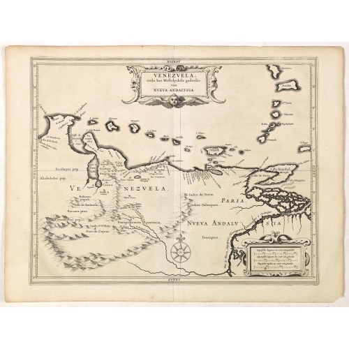
Venezuela, atque Occidentalis Pars Novæ Andalusiae.
Coastline of Venezuela with little interior development. Including Aruba, Bonaire, Curaçao, etc. Scarce map prepared by Hessel Gerritsz (1581-1632), former apprentice of Willem Blaeu, and Blaeu’s predecessor as chief cartographer of the Dutch East India Company. Gerritsz enjoys a very high reputation for his critical approach towards his sources.Most of Gerritsz’ work exists only in manuscript, and these maps published by de Laet, are among the only printed Gerritsz maps available to the co...
$600
Maker : LAET, DE J. / GERITSZ, H.
Place : Leiden, Elzevier
Date : 1630
![[French seizure of Chiorera.]](/uploads/cache/39911-500x500.jpg)
[French seizure of Chiorera.]
Scarce print with a German text sheet showing the French torching and looting Chiorera. From de Bry's "Great American Voyages". Johann Theodor de Bry (1561-1623) was born in Liège in 1561, the eldest son of the engraver and publisher Theodor de Bry. It was from his father that Johann learned his craft, producing both engravings and etchings. In 1588, the Lutheran De Bry family settled in Frankfurt am Main, a safe haven for Lutherans at this time of religious discord. Together with his father an...
$80
Maker : GOTTFRIED, J.L. / DE BRY.
Place : Frankfurt, M.Merian
Date : 1633
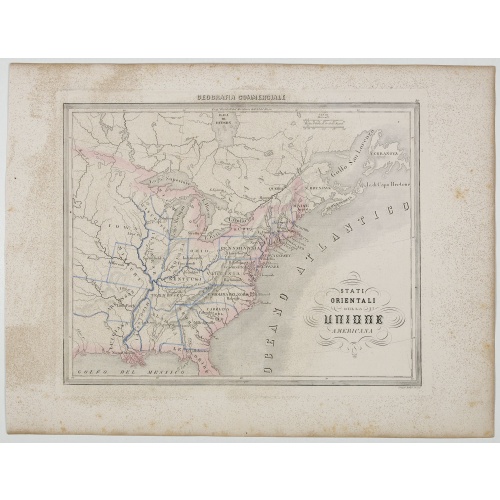
Stati Orientali della Unione Americana.
Uncommon map of Northeastern America prepared by Francesco Costantino Marmocchi. Above the map "Geografia Commerciale". From "Il Globo Atlante di carte Geografiche compilate da F.C. Marmocchi per servire di corredo al suu corso di geografia commerciale", with the maps engraved by engraved by Gius. Cattaneo, Campo Antico, C. Poggiali, G. Bonatti, and Ces. Magrini.Marmocchi (Poggibonsi, 1805-Geneva, 1858) was known as a geographer and cartographer. He emigrated to Rome, and later to Corsica, later...
€50
Maker : MARMOCCHI, F.C.
Place : Genova, Paolo Rivara fu Giacomo
Date : 1858
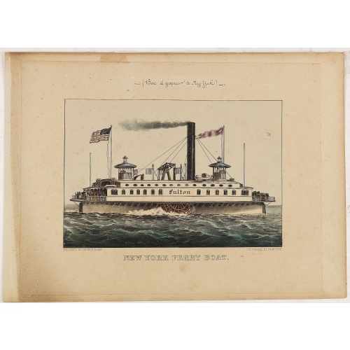
New York Ferry Boat. (Bac à vapeur de New York).
A very decorative print showing the New York Ferry Boat "Fulton," published by Currier & Ives. The Ferry boat "Fulton" sails to the right. A single smokestack trails smoke, and two flags blow to the left. Passengers, horses, and a carriage are visible on deck, and a captain is in the wheelhouse at right.Published by Currier & Ives 125 Nassau Street, New York."Currier & Ives was a New York publishing firm that produced and sold thousands of impressions of more than 7,000 different lithographic pr...
$550
Maker : CURRIER & IVES.
Place : New York
Date : ca. 1875
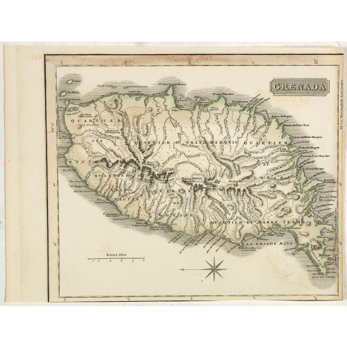
Grenada.
A delightfully detailed map the West Indian island Grenada by John Thomson. The map displays excellent detail concerning roads, rivers, towns, bays, harbours and other interesting topographical details.Thomson (1777-c1840) was a Scottish cartographer from Edinburgh, celebrated for his 1817 New General Atlas, published by himself in Edinburgh, John Cumming in Dublin, and Baldwin, Cradock, and Joy in London.
$50
Maker : THOMSON, J.
Place : Edenburgh
Date : 1821
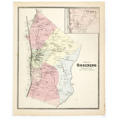
Town of Ossining. Westchester Co. NY.
Fine lithographed map of the town of Ossining. The map provides the names of specific homeowners, as well as information about the occupations and physical locations of the various tradesmen in each village from Beer's famous county atlas "Atlas of New York and vicinity, a documentary record of nineteenth-century life and delightful specimens of American folk art." F. W. Beers, along with other members of his family, were among the leading county atlas publishers in the period immediately follow...
$90
Maker : DE BEERS, F.W.
Place : New York
Date : 1867
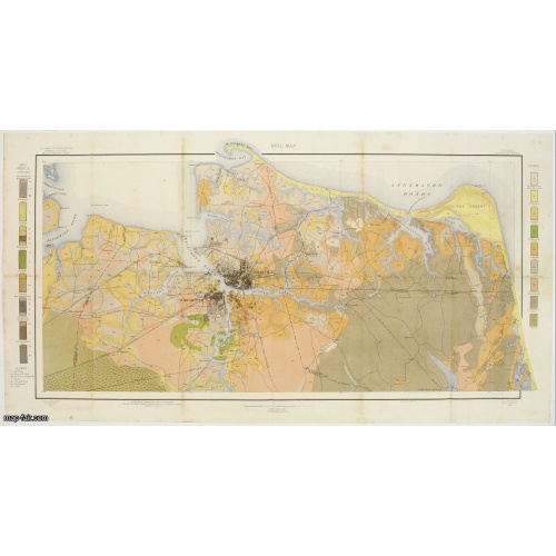
Soil map - Virginia Norfolk Sheet.
Soil map printed by Julius Bien & Co. in New York for the Department of Agriculture. The map gives great detail of the area centered on Norfolk, Potsmouth, Chesapeake, Virginia Beach in the year 1903. Soils are surveyed by J.E.Lapham in the same year. To the left and right, color keys to the different soil types.Upper left: U.S.Department of Agriculture, Bureau of soils, Milton Whitney, Chief.Julies Bien (later Bien & Co) was born and educated in Germany, and moved to America in 1849. He started...
$50
Maker : U.S. DEPT. OF ARGICULTURE
Place : New York 1903
Date : 1903
![[Black slaves escape punishment].](/uploads/cache/39920-500x500.jpg)
[Black slaves escape punishment].
Scarce print with a German text sheet. Many Black slaves, weary of ill treatment, managed to escape Spanish captivity and freely wandered the island, breaking into prisons and recruiting other slaves. Soon they outnumbered the Spanish and sought revenge by killing some of them. After a meeting at the governor’s palace in Santo Domingo, many Spanish soldiers were sent out to quell the rebellion by catching the Blacks by night and hanging them from trees. The Blacks learnt from this to keep a lo...
$80
Maker : GOTTFRIED, J.L. / DE BRY.
Place : Frankfurt, M.Merian, 1633
Date : 1633
-500x500.jpg)
View of Brewsters' Putnam Co.N.Y.
Heliographic print of Brewsters' Putnam Co.N.Y." after a design by R.K.Sneden.From Beer's famous county atlas "Atlas of New York and vicinity, a documentary record of nineteenth-century life and delightful specimens of American folk art". F. W. Beers, along with other members of his family, were among the leading county atlas publishers in period immediately following the Civil War. Their atlases provide "a detailed cartographical, biographical, and pictorial record of a large segment of rural A...
$90
Maker : DE BEERS, F.W.
Place : New York
Date : 1867
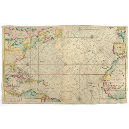
Nieuwe Wassende Graade Zee Kaart over de Spaanse Zee Vant Kanaal tot 't Eyland Cuba In Westindia.
Rare two-sheet blue-back sea chart of the Atlantic and Eastern part of North America., published by Gerard Van Keulen. The map extends from the latitude of Newfoundland and the English Channel in the north to the Equator in the south.In North America, most of the Great Lakes are shown and a large lake (Apalache Lac) in South Carolina. Florida is presented in a triangular shape.Florida is shown in a triangular model, with large islands forming the tip and numerous soundings along the coast. The ...
€2.500
Maker : VAN KEULEN, G.
Place : Amsterdam
Date : ca. 1728-1751

A Map of the most Inhabited part of New England containing the Provinces of Massachusetts Bay and New Hampshire, with the Colonies of Connecticut and Rhode Island.
A copper engraving in four sheets, published in Georges Louis Le Rouge, in his "Atlas Ameriqua in Septentrional Contenant les details des differentes provinces, de ce vaste continent, traduit des cartes levées par ordre du Gouvernement Britannique". This is a very close copy of the second edition, the second issue of the Jefferys-Green map, even down to the spelling, in the statement of sources, of Connecticut with 'k's (but translated into French). The title cartouche is also a straight copy, ...
€4.000
Maker : LE ROUGE, G. L.
Place : Paris, 1777
Date : Paris, 1777

Inventio Maris Magallanici.
Allegorical scene allegorical image celebrating the circumnavigation of the earth by Ferdinand Magellan. The image shows Magellan on board of his ship, surrounded by mythological figures including Apollo with sun and lyre, Zeus on his throne of clouds, Adam and Eve. A bird carrying an elephant and a depiction of the Tierra del Fuego.The image also includes cannon, banner with the double-headed Hapsburg eagle, anchor, broken mast, navigational instruments such as armillary sphere and dividers, se...
$400
Maker : DE BRY, Th.
Place : Frankfurt
Date : 1594
![[Lot of 2 maps] Important plan of Port Bucarelli 1384 / Chart of the entrance of "Bassin de L'Quest", La Perouse. 1709](/uploads/cache/20473-500x500.jpg)
[Lot of 2 maps] Important plan of Port Bucarelli 1384 / Chart of the entrance of "Bassin de L'Quest", La Perouse. 1709
Chart of the entrance of "Bassin de L'Quest", La Perouse. 1709 / With antique print of Alaska] Pirogue du port des Francais. / Pirogue, trouvee au port des Francais. 5958 / [Antique map of Alaska] Plan der Haven van Namganoodha in het eiland van Oonolaska. 2665 / Antique detail chart of the Nootka Channel] Schets van het Kanaal van Nootka. 3860. Plus 6 prints of natives of Alaska and their utensils. A plan of Port Bucarelli, Jean François Galoup, Comte de la Pérouse (1741-88), outstanding Fren...
€350
Maker : La Pérouse, J.B.G. Comte de.
Place : Paris
Date : 1797
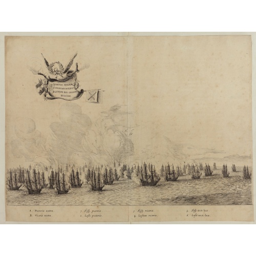
Quartum Praelium Coniovian inter et Fluvium Rio Grande XVII Ian
Decorative engraving of the fourth sea battle with the Portuguese fleet offshore at the Rio Grande, in 1640. Engraved by J. van Brosterhuyzen after a design by Frans J. Post (1612-1680). Below the engraving a numbered key (1-6). Signed in the plate "F. Post 1645" and decorative title cartouche, with "[Quartum praelium coniovian inter et fluvium Rio Grande XVII Jan" in the upper left corner.Taken from C. BARLAEUS, Rerum per octennium in Brasilia (...).
$450
Maker : POST, F. J.
Place : Joannes Blaeu, Amsterdam 1647
Date : 1647

Nieuwe Wassende Graade Zee Kaart over de Spaanse Zee Vant Kanaal tot 't Eyland Cuba in Westindia. . .
¤ Engraved by I.van Anse. A very representative example of a Dutch chart of the Atlantic, showing the north-east coast of America, the coasts of Africa and Europe and South America, including Florida and the West Indies. Gerard issued ca. 40 charts of this exceptionally large format. Collections of these large-size charts were issued in the shining sea-torch and as separate atlases.Title in Dutch, French and English. North America from Labrador to West Florida, including New Foundland, the Gulf...
$3.000
Maker : VAN KEULEN, G.
Place : Amsterdam
Date : 1728