
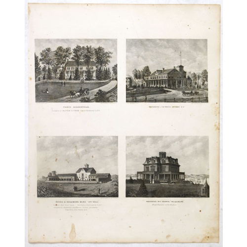
Todd Homestead / Résidence of B. Travis Katonah N.Y / Reisig & HexamersBarn Ivy Hill / Résidence of W.F Bearns
Four heliographic prints on one sheet : "Todd Homestead / Résidence of B. Travis Katonah N.Y / Reisig & HexamersBarn Ivy Hill / Résidence of W.F Bearns "Ingleuberg". After design by R.K.Sneden.From Beer's famous county atlas "Atlas of New York and vicinity", "a documentary record of nineteenth century life and delightful specimens of American folk art".F. W. Beers, along with other members of his family, were among the leading county atlas publishers in period immediately following the Civil W...
$90
Maker : DE BEERS, F.W.
Place : New York
Date : 1867
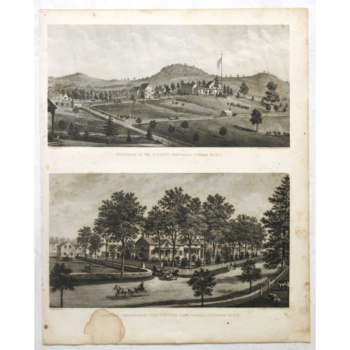
Résidence of WM H.Drew Southeast Putnam Co.N.Y / Lake Farm Résidence of John V.Storm East Fiskill Dutches Co.N.Y.
Two heliographic prints on one sheet : " Résidence of WM H.Drew Southeast Putnam Co.N.Y / Lake Farm Résidence of John V.Storm East Fiskill Dutches Co.N.Y." after design by R.K.Sneden.From Beer's famous county atlas "Atlas of New York and vicinity", "a documentary record of nineteenth century life and delightful specimens of American folk art". F. W. Beers, along with other members of his family, were among the leading county atlas publishers in period immediately following the Civil War. Their...
$90
Maker : DE BEERS, F.W.
Place : New York,1867
Date : 1867
-500x500.jpg)
View of Brewsters' Putnam Co.N.Y.
Heliographic print of Brewsters' Putnam Co.N.Y." after a design by R.K.Sneden.From Beer's famous county atlas "Atlas of New York and vicinity, a documentary record of nineteenth-century life and delightful specimens of American folk art". F. W. Beers, along with other members of his family, were among the leading county atlas publishers in period immediately following the Civil War. Their atlases provide "a detailed cartographical, biographical, and pictorial record of a large segment of rural A...
$90
Maker : DE BEERS, F.W.
Place : New York
Date : 1867
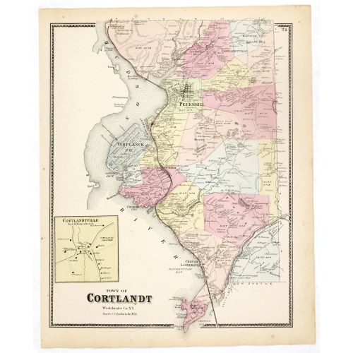
Town of Cortlandt.
Fine lithographed map of the town of Cortlandt. The map provides the names of specific homeowners, as well as information about the occupations and physical locations of the various tradesmen in each village from Beer's famous county atlas "Atlas of New York and vicinity", "a documentary record of nineteenth-century life and delightful specimens of American folk art." F. W. Beers, along with other members of his family, were among the leading county atlas publishers in the period immediately fol...
$90
Maker : DE BEERS, F.W.
Place : New York
Date : 1867
-500x500.jpg)
Town of Verplanck / Crugers / Croton Landing.
Fine lithographed map of the town of Verplanck / Crugers / Croton Landing. The map provides the names of specific homeowners, as well as information about the occupations and physical locations of the various tradesmen in each village from Beer's famous county atlas "Atlas of New York and vicinity," "a documentary record of nineteenth-century life and delightful specimens of American folk art." F. W. Beers, along with other members of his family, were among the leading county atlas publishers in...
$90
Maker : DE BEERS, F.W.
Place : New York
Date : 1867
-500x500.jpg)
Nouvelle carte de l'Amérique Septentrionale et des iles qui en dépendent dressée par H. Brué. . .
Very large, highly detailed, and uncommon issue of the map of North and Central America (ca. 1:13,888,000) prepared by H. Brué and improved by A.Vuillemin. Showing main interregional routes, rivers, and canals.The map was published in the year of The Texas Constitution of 1876. Texas still operates under the 1876 constitution today.Between the years of 1824 and 1876, Texas was at times a part of the United States of Mexico, an independent republic, a state within the Confederate States of Ameri...
$500
Maker : LOGEROT, A.
Place : Paris
Date : 1875
![Westelijk Halfrond. [Western hemisphere]](/uploads/cache/25524-500x500.jpg)
Westelijk Halfrond. [Western hemisphere]
Uncommon world map view of the western and eastern hemispheres of North and South America, Asia. Lithography by J.H. van Weijer, published in Atlas der geheele Aarde in 24 kaarten.
$50
Maker : SCHOLTENS, A.L.
Place : Groningen
Date : ca. 1860
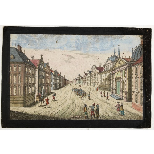
Prospect des Haupt Plazes der Untern Stadt zu Quebec.
A so-called optical print showing a decorative imaginary town view of Québec, with a street view with soldiers marching and pedestrians, an idealized view depicting Québec as a typical European city.By Franz Xavier Habermann (1721-1796).This print is a fine example of this illusionary printmaking, but also as a testament to the strong interest by Europeans in America at the time and also as a fine example of the perspective view.In the eighteenth and nineteenth centuries, there were many popul...
$500
Maker : ACADEMIE
Place : Augsburg, ca.1780
Date : 1780
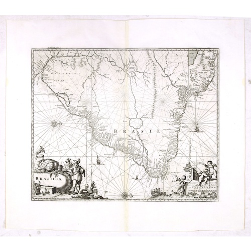
Brasilia.
Very fine decorative map od Brazil with west to the top. From the book "A Collection of Voyages and Travels" by Churchill and the map came from the part containing a description Nieuhoff's travels in Brazil.
$550
Maker : CHURCHIL, J.
Place : London, Printed for A. and J. Churchill
Date : 1703
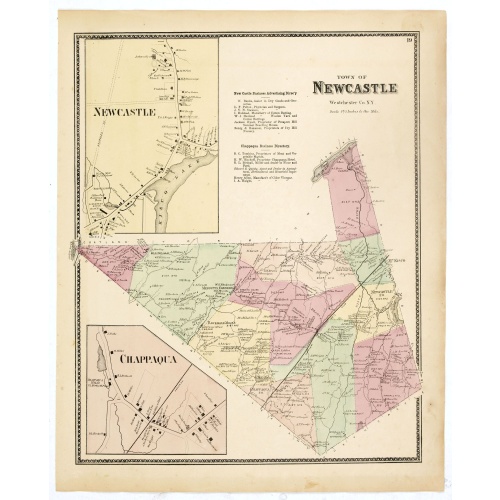
Town of New Castle. Westchester Co. NY.
Fine lithographed map of the town of New Castle. The map provides the names of specific homeowners, as well as information about the occupations and physical locations of the various tradesmen in each village from Beer's famous county atlas "Atlas of New York and vicinity, a documentary record of nineteenth-century life and delightful specimens of American folk art." F. W. Beers, along with other members of his family, were among the leading county atlas publishers in the period immediately foll...
$90
Maker : DE BEERS, F.W.
Place : New York, 1867
Date : 1867
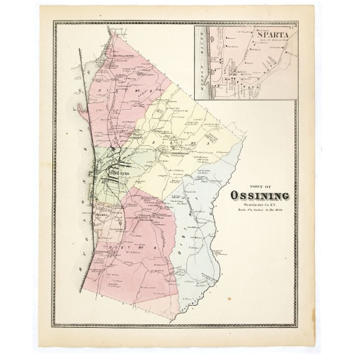
Town of Ossining. Westchester Co. NY.
Fine lithographed map of the town of Ossining. The map provides the names of specific homeowners, as well as information about the occupations and physical locations of the various tradesmen in each village from Beer's famous county atlas "Atlas of New York and vicinity, a documentary record of nineteenth-century life and delightful specimens of American folk art." F. W. Beers, along with other members of his family, were among the leading county atlas publishers in the period immediately follow...
$90
Maker : DE BEERS, F.W.
Place : New York
Date : 1867
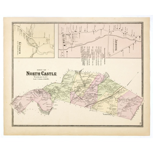
Town of North Castle.
Fine lithographed map of the town of North Castle. The map provides the names of specific homeowners, as well as information about the occupations and physical locations of the various tradesmen in each village from Beer's famous county atlas "Atlas of New York and vicinity, a documentary record of nineteenth-century life and delightful specimens of American folk art." F. W. Beers, along with other members of his family, were among the leading county atlas publishers in the period immediately fo...
$90
Maker : DE BEERS, F.W.
Place : New York
Date : 1867
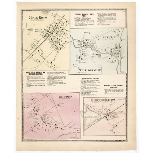
Mount Kisco / Bedford / Katonah / Bedford Station.
Fine lithographed map of Mount Kisco / Bedford / Katonah / Bedford Station. The map provides the names of specific homeowners, as well as information about the occupations and physical locations of the various tradesmen in each village from Beer's famous county atlas "Atlas of New York and vicinity, a documentary record of nineteenth-century life and delightful specimens of American folk art." F. W. Beers, along with other members of his family, were among the leading county atlas publishers in ...
$90
Maker : DE BEERS, F.W.
Place : New York
Date : 1867
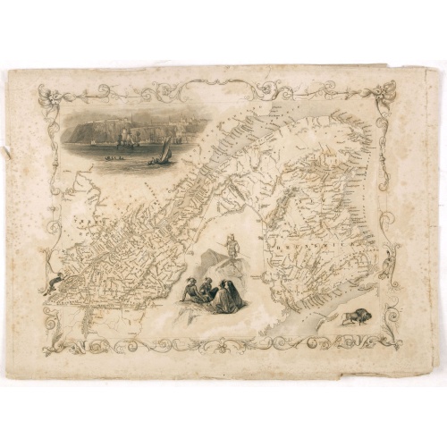
East Canada and New Brunswick.
This is John Tallis’ map of East Canada or what is now Quebec and New Brunswick. Includes Montreal, Quebec City, and the St. Lawrence River valley. Features five vignettes which include American Indian warriors and a spectacular view of Quebec City. The whole is surrounded by a decorative vine motif border. The vignettes for this map were drawn by H. Warren and engraved by J. B. Allen. The map itself is the work of John Rapkin. The Illustrations after a design by H. Warren and engraved by J Ra...
$75
Maker : TALLIS, J.
Place : London
Date : 1851
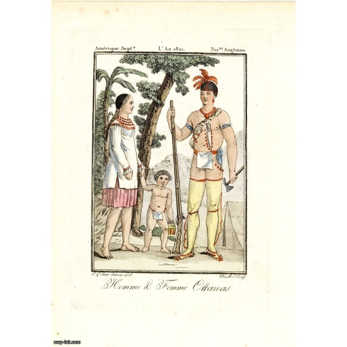
Homme & Femme Ottawas.
Hand-colored mezzotint of Native Americans engraved by Félix Mixelle and Lachaussée Jeune after Jacques Grasset de Saint-Sauveur.As an etcher, drawer and writer, Grasset de Saint-Sauveur was a prolific polygraph in keeping with the encyclopedic spirit of the eighteenth century: he wrote exotic novels as well as documentary works on various subjects. Called by one of his biographers a drawer without genius but a good example of the taste of his time, Grasset de Saint-Sauveur was literally bewit...
$75
Maker : GRASSET DE SAINT SAUVEUR,J.
Place : Paris,
Date : 1806
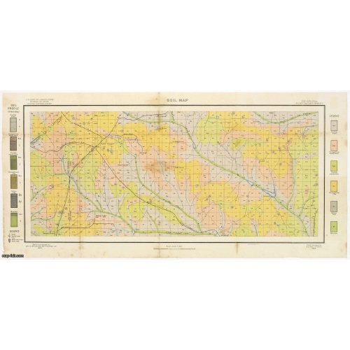
Soil map - Georgia, Fort Valley sheet.
Early color lithographed soil map by Julius Bien & Co. in New York for Department of Agriculture. Legends at side give detail on soil type, etc. They also include interesting details of the cities, roads, railroads, rivers, canals, etc. Scale of 1" = 1 mile. The map is giving great detail of the area in the year 1903. Soils are surveyed by Wm. G. Smith and Wm. T. Carter Jr. in the same year. To the left and right color keys to the different types of soil.Upper left: U.S.Department of Agricult...
$50
Maker : U.S. DEPT. OF ARGICULTURE
Place : New York, 1903
Date : 1903
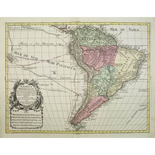
America Meridionalis.
This is the more scarce edition with the title cartouche lower left surrounded by Neptune and a native Indian.A rather accurate depiction and descriptions of South America. Brazil is slightly enlarged and bears mainly names of the costal zone. The inland was rather unknown at the time and regarded as both pagan and dangerous area like the Amazon.Argentina with Cape Horn and the Falkland Islands are merely deformed. The map was published by Matthäus Seutter's son in law Tobias Conrad Lotter, who...
€550
Maker : LOTTER, T.C.
Place : Augsburg
Date : c. 1760

Karte der Magellanischen-Strasse. . .
Very detailed map of Strait of Magellan, with in top inset map of Southern tip of South America with the Falklands. Prepared by Don Juan de La Cruz of Spain.Engraved by Jos. Gestner.
€600
Maker : SCHRAEMBL, F.A.
Place : Vienna
Date : 1787
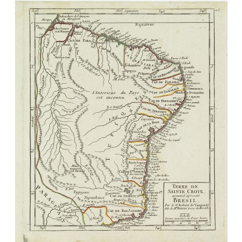
Terre de Sainte Croix, nommée à présent Bresil.
Detailed small map showing most part of the Brazilian seacoasts, from the mouth of the Amazon River as far as the island of Sao Sebastiao.From Atlas Portatif Universel, by Robert de Vaugondy. 111 outside border top right. Mary Sponberg Pedley does not mention a state without date.
€75
Maker : VAUGONDY, R. de
Place : Paris
Date : later than 1749
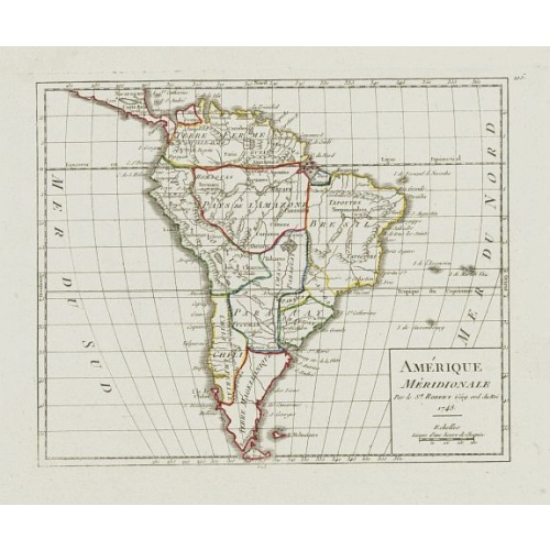
Amérique Méridionale.
Nice small map of South America. Dated 1748. From Atlas Portatif Universel, by Robert de Vaugondy.Page 105 outside border top right. Mary Sponberg Pedley does not mention a state without date.
€75
Maker : VAUGONDY, R. de
Place : Paris
Date : later than 1748