

Quartum Praelium Coniovian inter et Fluvium Rio Grande XVII Ian
Decorative engraving of the fourth sea battle with the Portuguese fleet offshore at the Rio Grande, in 1640. Engraved by J. van Brosterhuyzen after a design by Frans J. Post (1612-1680). Below the engraving a numbered key (1-6). Signed in the plate "F. Post 1645" and decorative title cartouche, with "[Quartum praelium coniovian inter et fluvium Rio Grande XVII Jan" in the upper left corner.Taken from C. BARLAEUS, Rerum per octennium in Brasilia (...).
$450
Maker : POST, F. J.
Place : Joannes Blaeu, Amsterdam 1647
Date : 1647
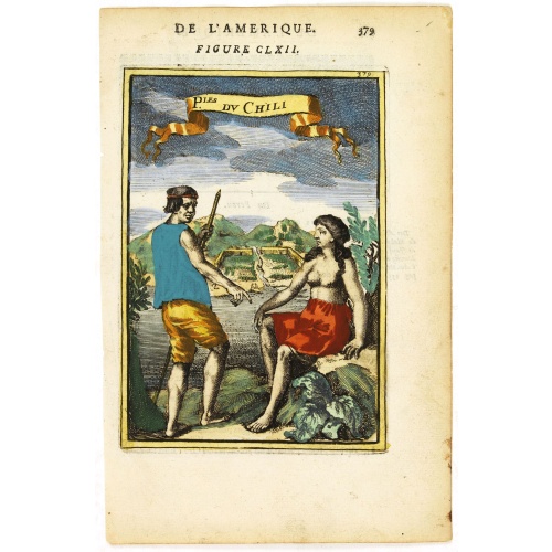
P.les du Chile.
A charming copper engraving depicting a town surrounded by a luxuriant landscape on the background and a couple of indigenous on the foreground.From the French text edition of Description d'Univers, 1683. by Allain Manneson Mallet (1630-1706), a well traveled military engineer and geographer who worked in 17th century France under King Louis XIV.
€60
Maker : MALLET, A.M.
Place : Paris
Date : 1683
Pas kaart Van Rio Oronoque Golfo De Paria met d'Eylanden Trinidad, Tabago, Granada, Granadillos, en Bequia . . .
A highly detailed and rare sea chart of the mouth of the Orinoco River, Trinidad, Tabago, St.Vincent and neighboring islands. Oriented with north to the right by two compass roses.A large inset shows Tobago on a larger scale. Taken from De Nieuwe Groote Lichtende Zee-Fakkel, Part IV.Decorative scale cartouche features Neptune with his entourage and natives with trade goods. The chart is further adorned with a monkey atop the title cartouche and a sailing ship.
$900
Maker : VAN KEULEN, J.
Place : Amsterdam
Date : 1684
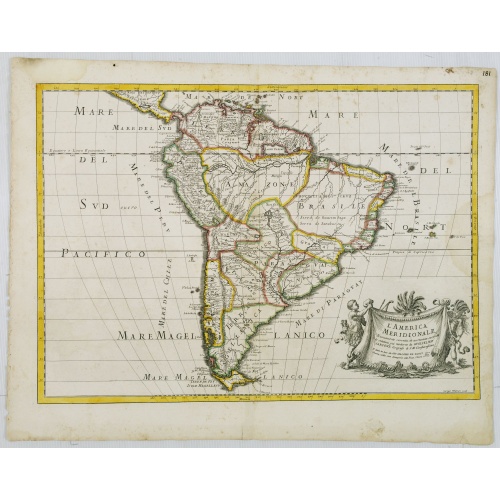
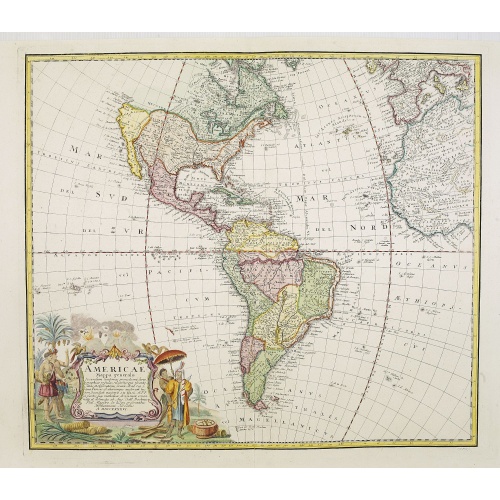
L'America Meridionale . . .
The second edition of Rossi's map of South America, based upon Sanson's map, but with revised Italian nomenclature. From his 'Mercurio Geografico...'. The engraver was Giorgio Widman. With a large title cartouche in the lower right.
€900
Maker : ROSSI, G.G.
Place : Rome
Date : 1687
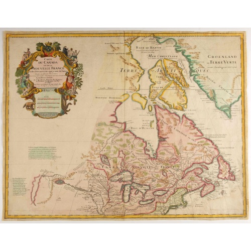
Carte du Canada ou de la Nouvelle France.
Fourth state of the map of Canada published by Delisle with the imprint "sur le Quai de l’Horloge a l’Aigle d’Or avec Privilege pour 20 ans, 1703". Beneath the title, Renard’s imprint is erased.Including the fictitious discoveries of Baron de Lahoutan: the legendary River Longue etc. The north west corner of Hudson Bay is left open, leaving the possibility of a north west passage open. De l'Isle's map was the first to show Detroit (founded by Cadillac) and the first to mention a settleme...
€500
Maker : DE L'ISLE, G.
Place : Paris
Date : 1703
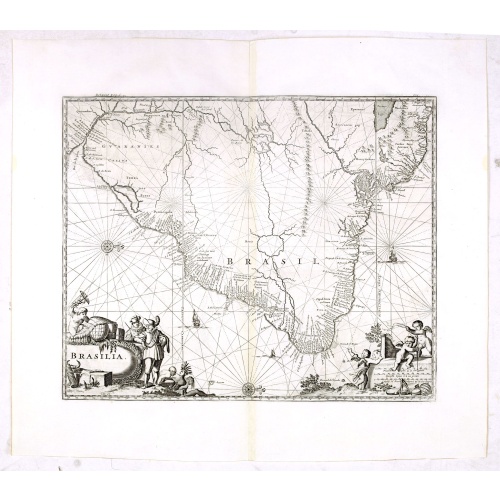
Brasilia.
Very fine decorative map od Brazil with west to the top. From the book "A Collection of Voyages and Travels" by Churchill and the map came from the part containing a description Nieuhoff's travels in Brazil.
$550
Maker : CHURCHIL, J.
Place : London, Printed for A. and J. Churchill
Date : 1703
Nieuwe gelyk Graadige Paskaart van de Kust van Guiana in West-Indien.
Detailed chart of Guiana in South America. Two scales are given in both maps: Dutch, French and English nautical miles.The inset chart provide detailed view of the Camopi and Maroni or Marowijne Rivers that forms the border between French Guiana and Suriname. The charts are prepared by Johannes Loots and H.Mooy.
$650
Maker : VAN KEULEN, G.
Place : Amsterdam
Date : 1684 - 1704

Particularitez Curieuses de l'Ile de St. Christophle et de la Province de Bemarin . . .
Six meticulously detailed and engraved scenes of the island of St. Kitts, also known as Saint Christopher, and the province of Bemarin, indigenous plants, animals, reptiles, fish, crustaceans and insects.On a single sheet from Volume Six of Chatelain's "Atlas Historique".From left to right, top, the illustrations depict the French General's palace on St. Kitts, Indians visiting the French, and a landscape in Bemarin Province. Zacharie Chatelain (d.1723) was the father of Henri Abraham (1684-1743...
€95
Maker : CHATELAIN, H.
Place : Amsterdam
Date : 1720
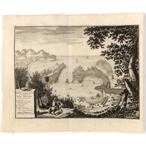
Haven van Aquapulco in ' Coninkryk van Nova Spagnien in de Zuyd Zee.
A finely engraved plan of the harbor, fort and village of Acapulco drawn from a hilltop vantage point looking out to sea. Several galleons are pictured approaching or anchored in the harbor. After Johannes Vingboons.François Valentijn (1666-1727), a missionary, worked at Amboina from 1684 to 1694 and 1705 to 1713 and traveled extensively in the VOC's lands. He is best known for his monumental history and description, "Oud en Nieuw Oost-Indiën" which remains one of the most important primary so...
€650
Maker : VALENTIJN, F.
Place : Amsterdam
Date : 1726
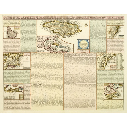
Carte qui contient..Iles & Terres..L'Amerique..Jamaique..
Eight maps on one sheet. From Chatelain's Atlas Historique et Méthodique . Including maps of Bermuda, Jamaica, New England with Long Island, Carolina, Chesapeake and Delaware Bay, Nova Scotia and a map of the Caribbean.
€500
Maker : CHATELAIN, H.
Place : Amsterdam
Date : 1728

Nieuwe Wassende Graade Zee Kaart over de Spaanse Zee Vant Kanaal tot 't Eyland Cuba in Westindia. . .
¤ Engraved by I.van Anse. A very representative example of a Dutch chart of the Atlantic, showing the north-east coast of America, the coasts of Africa and Europe and South America, including Florida and the West Indies. Gerard issued ca. 40 charts of this exceptionally large format. Collections of these large-size charts were issued in the shining sea-torch and as separate atlases.Title in Dutch, French and English. North America from Labrador to West Florida, including New Foundland, the Gulf...
$3.000
Maker : VAN KEULEN, G.
Place : Amsterdam
Date : 1728
L'Amerique septentrionale, Dressée sur les memoires les plus recens. . .
A very detailed map extending from Hudsons Bay to Panama, and including the West Indies. The map is a later copy of Guillaume de L'Isle's foundation map of North America, originally prepared in 1700.The de L'Isle was one of the earliest maps to restore the peninsula form for California, and has a much improved outline for the Great Lakes and Mississippi valley.The map shows select towns and cities, forts, Indian villages and tribal territory and relief.
$900
Maker : COVENS, J. / MORTIER, C.
Place : Amsterdam
Date : 1739
Carte d'Amerique dressée par l'usage du Roy..
Fine map prepared by G.d'Isle depicting North and south America, the west coast taken north to Cap Mendocin and Cap Blanc with a note Entrée decouverte par Martin d'Aguilar .The re-engraved Amsterdam edition, with the lettering within the title cartouche copied from the issue of the first edition with the florid lettering for d'Amerique. Dated 1739.
€700
Maker : COVENS, J. / MORTIER, C.
Place : Amsterdam
Date : 1739
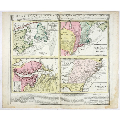
Dominia Anglorum in America Septentrionali.
Four maps on one sheet (New Found land/ New England/ Virginia and Carolina/Florida) based on J.B.Homann's map, showing British possessions in North America. The upper left shows territory in Newfoundland and around the Bay of St. Lawrence, with portions of the ‘lost’ colony of New Scotland. The Grand Banks are prominently noted as well. The map immediately to the right shows claims in New York and New England, with large areas in Pennsylvania noted as belonging to the Iroquois. The lower lef...
€750
Maker : HOMANN HEIRS.
Place : Nuremberg 1740
Date : 1740
Dominia Anglorum in praecipuis Insulis Americae ut sunt Insula S. Christopheri, Antegoa, Iamaica, Barbados nec non Insula Bermudes vel Sommers . . .
Four maps of the islands of West Indies (St. Christoph "Delineatio Insulae St, Christophori alias I. Kitts", Antigua "Insula Antegoa", Barbados "Insula Barbadoes" and Iamaica "Insula Iamaica") and a map of Bermudas ("Insulae Bermudes") showing British possessions in the Caribbean. At the upper right of the sheet text in German relating to the areas depicted.A second edition with Bermudes. The first edition uses the name Bermudos.
$500
Maker : HOMANN HEIRS.
Place : Nuremberg
Date : 1740
Americae Mappa generalis.
Johann Baptist Homann's well-engraved second map of America has a large decorative cartouche. Detailed map of the western hemisphere.The interior of North America has new details supplied by the Jesuits, especially along the Mississippi River and English and Dutch information along the coast.The Great Lakes after D'Anville. The NW Coast of America and NW Passage are still unknown. Quivira -the legendary land of gold and silver- is shown considerably east of its normal location. Johann Baptist Ho...
€700
Maker : HOMANN HEIRS. / HAAS, J.M.
Place : Nuremberg
Date : 1746
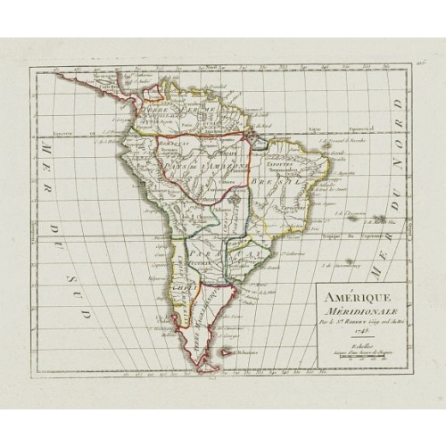
Amérique Méridionale.
Nice small map of South America. Dated 1748. From Atlas Portatif Universel, by Robert de Vaugondy.Page 105 outside border top right. Mary Sponberg Pedley does not mention a state without date.
€75
Maker : VAUGONDY, R. de
Place : Paris
Date : later than 1748
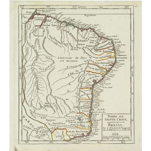
Terre de Sainte Croix, nommée à présent Bresil.
Detailed small map showing most part of the Brazilian seacoasts, from the mouth of the Amazon River as far as the island of Sao Sebastiao.From Atlas Portatif Universel, by Robert de Vaugondy. 111 outside border top right. Mary Sponberg Pedley does not mention a state without date.
€75
Maker : VAUGONDY, R. de
Place : Paris
Date : later than 1749

Partie du Mexique ou de la Nouvelle Espagne Où se trouve l'Audience de Guatimala.
Nice small map of Central America, extending from the Yucatán Peninsula to Panama. From Atlas Portatif Universel, by Robert de Vaugondy.From Atlas Portatif Universel, by Robert de Vaugondy.Page 89 outside border top right. Mary Sponberg Pedley does not mention a state with this number.
€50
Maker : VAUGONDY, R. de
Place : Paris
Date : later than 1749
Nieuwe Wassende Graade Zee Kaart over de Spaanse Zee Vant Kanaal tot 't Eyland Cuba In Westindia.
Rare two-sheet blue-back sea chart of the Atlantic and Eastern part of North America., published by Gerard Van Keulen. The map extends from the latitude of Newfoundland and the English Channel in the north to the Equator in the south.In North America, most of the Great Lakes are shown and a large lake (Apalache Lac) in South Carolina. Florida is presented in a triangular shape.Florida is shown in a triangular model, with large islands forming the tip and numerous soundings along the coast. The ...
€2.500
Maker : VAN KEULEN, G.
Place : Amsterdam
Date : ca. 1728-1751