
![[Ternate].](/uploads/cache/37954-500x500.jpg)
[Ternate].
Text engraving showing a bay on the Island of Ternate, an island in the Maluku Islands (Moluccas) of eastern Indonesia. Above the map a lettered key (A-E). Text engraving from "Premier livre de l'histoire de la navigation aux Indes Orientales, par les hollandois, et des choses a eux advenues . . . ", being the classic account of the first Dutch voyage to the East Indies under the command of Cornelis de Houtman. the expedition left in 1595, after Holland had achieved independence from Spain and c...
$150
Maker : LODEWYCKSZ, Willem
Place : Amsterdam, Cornille Nicolas
Date : 1609
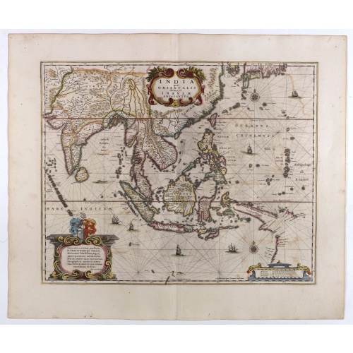
India quae Orientalis dicitur, et Insulae adiacentes.
A fine map of South East Asia, extending from India to Tibet to Japan to New Guinea. Formosa appears on this map, and even parts of Japan and Australia are seen. A handsome map in the typically baroque Dutch style.Noteworthy for being the second map to include the discoveries made in New Guinea and northern Queensland, Australia by the Dutch vessel Duyfken in 1605-06. Under the command of Willem Janzoon, the Duyfken explored the eastern shore of the Gulf of Carpentaria, just below the Cape York ...
$1.850
Maker : JANSSONIUS, J. / HONDIUS, H.
Place : Amsterdam
Date : 1640
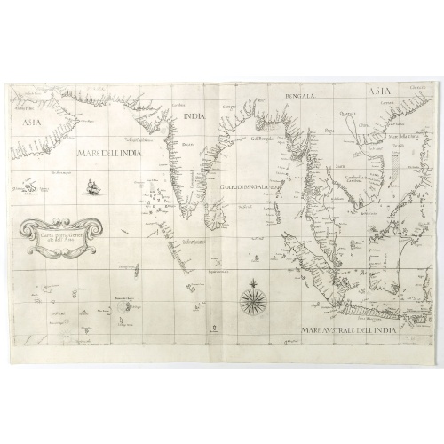
Carta prima Generale dell' Asia.
FIRST STATE of Robert Dudley's general chart of the Persian Gulf, going east through India to the southeastern coast of China showing Macau and the area of present-day Hong Kong. The map goes south through the Philippines, passing through Borneo, the western part of Celebes (now Sulawesi, Indonesia). It also includes the Maldives and the Chagos Archipelago.This elegant sea chart is crisply engraved in the sparse Florentine style with superb calligraphy throughout. Very decorative chart from the ...
$17.500
Maker : DUDLEY, R.
Place : Florence
Date : 1646
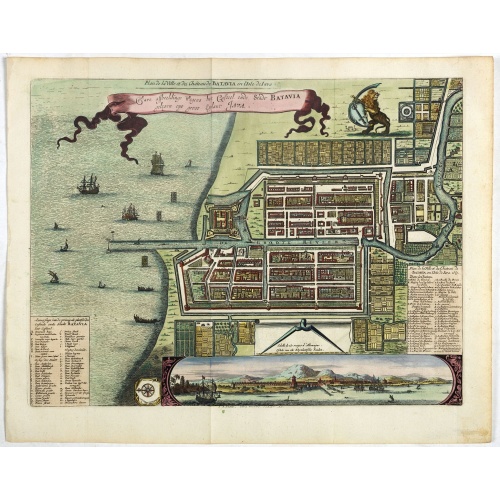
Ware affbeeldinge wegens het casteel ende stadt Batavia. . .
A reduced version of Clement de Jonghe (1650) plan of Jakarta from 1650. The town plan has a vignette at the bottom showing Jakarta from the sea with the volcanoes Mount Gede, Mount Pangrnago and Mount Salak in the background. Engraved for Arnoldus Montanus "Gedenkwaerdige gesantschappen der Oost-Indische maatschappy in ’t Vereenigde Nederland. . ." (1669) but reissued by Pieter van der AA.Batavia, present-day Jakarta, the Dutch center of trading activities in the East Indies. European and nat...
$800
Maker : VANDER AA, P.
Place : Leiden
Date : 1719
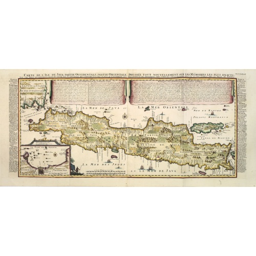
Carte de l'Ile de Java. . .
An inset plan of Batavia and clearly indicated rice fields, mountains, forests, towns in profile, and even elephants, suggesting the wealth of detail found on this map. Modeled on Hadrien Reland's important Dutch map of a few years earlier, the superb topographical detail is complemented by drapery style cartouche and side panels which provide a full French text description of the island, its topography, history, flora, fauna and inhabitants. Above the map are two drapery style title banners wri...
$1.750
Maker : CHATELAIN, H.
Place : Amsterdam
Date : 1720
![[Set of 2 maps of Caspian Sea.] Carte marine de la Mer Caspiene. Levee suivant les ordres de S.M. Czariene, P](/uploads/cache/86020-(1)-500x500.jpg)
[Set of 2 maps of Caspian Sea.] Carte marine de la Mer Caspiene. Levee suivant les ordres de S.M. Czariene, P
Guillaume de l' Isle (1675-1724), Royal Geographer, was the most influential cartographer of the first quarter of the 18th century. ' Atlas de Géographie' (1700-12), posthumous ' Atlas Nouveau' (1730). After the death of the widow of Pieter Mortier in 1719, the firm continued till 1778 as Covens & Mortier. They published numerous atlases and pocket atlases, using maps after de l' Isle and Jaillot.Two charts together depicting the Caspian Sea; the northern part of the Caspian Sea with insets dep...
€350
Maker : Guillaume Delisle
Place : Paris
Date : 1721
![[Lot of 10 maps] Carte Nouvelle de la Grande Tartary.](/uploads/cache/85969-500x500.jpg)
[Lot of 10 maps] Carte Nouvelle de la Grande Tartary.
Antique map of Asian Russia] Carte Nouvelle de la Grande Tartarie ou de l'Empire du Grand Cham. With 10 maps / views of Asian Russia- Carte Nouvelle de la Grande Tartarie ou de L’empire du Grand Cham (1719)- Baie de castries settee sur la cote orientale de tartarie (1797)- Carte du Kamtchatka Dressee et Gravée par Laurent (1757)- 2x Gezichten der kust van Asiën.- Gezichten der kust van Kamtchatka.- Carte de la Tartarie Occidentale, Pour servir à l'Histoire Générale (1749)- IImperium Rus...
€700
Maker : CHATELAIN, H.
Place : Amsterdam
Date : 1720 - 1730
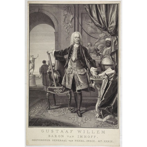
Gustaaf Willem Baron van Imhoff.
Decorative portrait of Gustaaf Willem Baron van Imhoff, who was Governor for the V.O.C. (Dutch East Indian Company) in Indonesia.
$750
Maker : TANJÉ, P.
Place : Amsterdam
Date : 1745
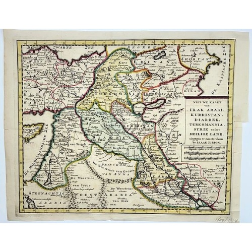
Irak, Arabi, Kurdistan, Diarbek, Turkomania, Syrie en het Heilige Land.
Isaak Tirion's map of the Near East. His 'Nieuwe en beknopte handatlas' saw 6 editions between before 1740 and after 1784. Also the 'Atlas van de Nederlandse Provintien' (1739-57) and ' Atlas van Zeeland' (1760).
€350
Maker : TIRION, Isaak.
Place : Amsterdam
Date : ca. 1750
![[Lot of 13 prints of the Chinese court] Habillement de l' Empereur dela Chine & des Dames de son Palais aves quel...](/uploads/cache/IMG_08451-500x500.jpg)
[Lot of 13 prints of the Chinese court] Habillement de l' Empereur dela Chine & des Dames de son Palais aves quel...
Prints of the Chinese court.[Lot of 13 prints]- Salle Imperiale De L'Audience, tiree de Nieuhof (1760)- Pagodes ou Statues; Miniso ou la Volupté (1749- Pagodes ou statues du temple. 1. Un defenseur de la patrie.- Mandians vacabonds / Autres mandais - Pagodes ou statues du temple- Salle Imperiale de l'Audience tiree de Nieuhof- Laboureurs (1750)- Cour du Grand Mogol- l'ambassadeur conduit a l’audience- Le Grand Throne Imperial.- Mandians Vagabonds. Autres Mandians / Zwervende Schooije...
€400
Maker : BELLIN, J.N.
Place : Amsterdam
Date : 1750
![[Lot of 6] Carte de la Baye d'Hocsieu. Fukin. (3 Maps + 3 Gravure of China)](/uploads/cache/20019-500x500.jpg)
[Lot of 6] Carte de la Baye d'Hocsieu. Fukin. (3 Maps + 3 Gravure of China)
[Lot of 6 items]. (3 Maps +3 gravure )- Carte de la Baye d'Hocsieu et des Entrees de la Riviere de Chang Situees dans la Province de Fokyen. J.N.Berlin 1748- Carte de l’Isle de Cheu Chan ou Isle de Chusan de la Province de Che-Kiang Avec les Costes et Isles voisines- Carte de la Baye d'Hocsieu et des Entrées de la Riviere de Chang. Situées, Dans la Province de Fokyen- Tempel van Quang-Que-Myau- Temple Chinois- De Seije-Reedery, uit de HaldeA detailed small chart of the estuary of the Chiang...
€280
Maker : BELLIN, J. N.
Place : Amsterdam
Date : 1759

Eastern passage to China. sheet 1.
James Horsburgh early chart of the coasts of Java, Bali, Lombok, with part of Sulawesi, and Borneo. Insets of "Sketch of Bally Strait", Sketch of Lombock Strait", Plan of Allas Strait", "Sketch of Sappy Strait".The chart shows depth soundings & both topographical and hydrographical details and proposed sailing directions in the Sunda Straits. Filled with several coastal profiles, which were of great help for the sailor.In top Horsburgh thanks for the aid he has gotten for preparing this chart : ...
$3.000
Maker : HORSBURGH, JAMES, F.R.S
Place : London
Date : 1824
-500x500.jpg)
Kaart van de Gaspar Straaten volgens opnemingen van J.Stolze, D.Ross, enz.
Very large and rare chart centered on the strait between Bangka's southeastern seacoast and Belitung's western shores.Short front views of the coastal relief are shown in the lower-left corner of the map.The chart is prepared by H.L.Osthoff in 1840 and published in 1844 by Jacob Swart. When Gerard Hulst van Keulen died in 1801, his widow ran the firm until her death in 1810, at which time Johannes Hulst van Keulen became the last van Keulen to run the firm.In 1823, Jacob Swart entered the servic...
$900
Maker : HULST VAN KEULEN, Wed.G.
Place : Amsterdam
Date : 1843

Straat Riouw onder opzicht van de commissie tot verbetering der Indische Zeekaarten..
Very large and rare so-called Blue Back chart centered on the strait passing between the Riau Islands. It contains an inset map with enlarged details of Riouw Harbor on Bintang Island.Coastal profiles are shown in the lower-left corner of the chart.The chart is prepared by W.H.Dittlof Tjassens, P.A.J.Bloijs van Treslong Prins and J.van Gogh during an expedition in 1840 by the ship Nehalennia under the command of Captain F.G.van der Plaat. The chart is engraved by D.Veelwaard Jr. And published in...
$1.250
Maker : HULST VAN KEULEN, Wed.G.
Place : Amsterdam
Date : 1843

Kaart van de Reede van Batavia met de verschillende vaarwaters naar dezelve trigometrisch opgenomen op last van deb schout bijnacht E.Lucas.
Very large and rare so-called blue-black chart centered on Jakarta's harbor.The chart is prepared by B.G.Escher, I.A.C. Eschauzier, B.H.Staring and E.H.Boom during an expedition in 1841 by the ships Krokodil and Hekla. The chart is engraved by J.C.Zurcher and updated for and published in 1847 by Jacob Swart. When Gerard Hulst van Keulen died in 1801, his widow ran the firm until her death in 1810, at which time Johannes Hulst van Keulen became the last van Keulen to run the firm.In 1823, Jacob S...
$1.800
Maker : HULST VAN KEULEN, Wed. G.
Place : Amsterdam
Date : (1841) 1847