
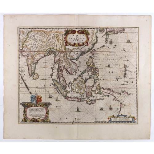
India quae Orientalis dicitur, et Insulae adiacentes.
A fine map of South East Asia, extending from India to Tibet to Japan to New Guinea. Formosa appears on this map, and even parts of Japan and Australia are seen. A handsome map in the typically baroque Dutch style.Noteworthy for being the second map to include the discoveries made in New Guinea and northern Queensland, Australia by the Dutch vessel Duyfken in 1605-06. Under the command of Willem Janzoon, the Duyfken explored the eastern shore of the Gulf of Carpentaria, just below the Cape York ...
$1.850
Maker : JANSSONIUS, J. / HONDIUS, H.
Place : Amsterdam
Date : 1640
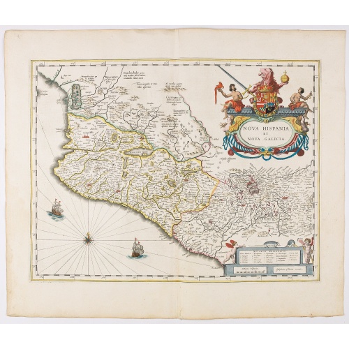
Nova Hispania et Nova Galicia.
Map of New Spain and New Galicia shows the city of Mexico situated by a large lake, as well as the location of many silver and gold mines. The map's elaborate cartouche is surmounted by the Spanish Royal coat of arms. Based on Ortelius map of 1579 which became the basis for many of the seventeenth century maps of the area. From early on Willem Jansz. Blaeu aimed of publishing an atlas to compete with the Hondius-Jansson Atlas. By 1630, he had published at least 17 folio size maps. Blaeu was ab...
€850
Maker : BLAEU, W.
Place : Amsterdam
Date : 1644
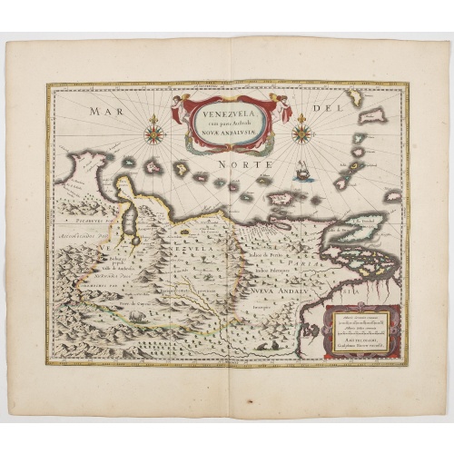
Venezuela cum parte Australi Novae Andalusiae.
A finely engraved, decorative map of Venezuela. The islands of Trinidad and Tobago, Margarita, Aruba and Curaçao are shown. Local animals are depicted, sheep, birds, monkeys.With a decorative title cartouche held aloft by a pair of winged cherubs and a handsome pair of compass roses, galleon etc. From early on Willem Jansz. Blaeu aimed of publishing an atlas to compete with the Hondius-Janssonius Atlas. By 1630, he had published at least 17 folio size maps. Blaeu was able to realize his plan s...
€800
Maker : BLAEU, W.
Place : Amsterdam
Date : 1644
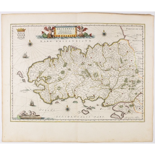
Britannia Ducatus. Duché de Bretaigne.
Map of Bretagne in France. From early on Willem Jansz. Blaeu aimed of publishing an atlas to compete with the Hondius-Jansson Atlas. By 1630, he had published at least 17 folio size maps. Blaeu was able to realize his plan soon after he had acquired the copper plates of the atlas maps by Jodocus Hondius. The "Appendix followed in 1630.In 1635 he finally realized a "international edition" of a world atlas, the "Theatrum Orbis Terrarum".
€650
Maker : BLAEU, W.
Place : Amsterdam
Date : 1644

Europa recens descripta à Guilielmo Blaeuw.
On either side columns depicting the manner of dress in the major countries of Europe, surmounted by nine city views and plans.For European mapmakers their own continent contained few mysteries or secrets by the seventeenth century. However, the mythical island of Frisland still appears between Iceland and Greenland. The map is decorated with ships and a sea monster on the sea, bears on northern Russia, and lions on North Africa.
€3.250
Maker : BLAEU, W.
Place : Amsterdam
Date : 1644
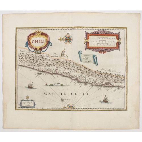
Chili.
Willem Blaeu's very decorative map of Chili with two large and beautiful cartouches, a compass and ships. From early on Willem Jansz. Blaeu aimed of publishing an atlas to compete with the Hondius-Janssonius Atlas. By 1630, he had published at least 17 folio size maps. Blaeu was able to realize his plan soon after he had acquired the copper plates of the atlas maps by Jodocus Hondius. The "Appendix followed in 1630.In 1635 he finally realized a "international edition" of a world atlas, the "The...
$900
Maker : BLAEU, W.
Place : Amsterdam, 1644
Date : 1644
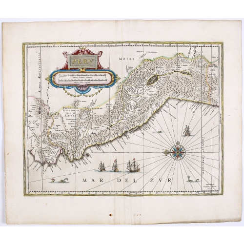
Peru.
FIRST EDITION, FIRST ISSUE OF THIS MAP. Decorated with ships and monsters in the sea. Orientated with east at the top. With the signature of G. Blaeuw lower right corner. Shows the Pacific coast of South America from Ecuador (at the left-hand side) as far south as the Atacama desert in the northern reaches of Chile. "As early as 1520, Spanish settlers in Panama had heard tales of a powerful civilization rich in gold that lay to the south, and in 1522 an expedition was organized to find this land...
€900
Maker : BLAEU, W.
Place : Amsterdam
Date : 1644

Insulae Divi Martini et Uliarus, vulgo L'Isle de Ré.. Oleron.
Map of Ré and Oléron islands. Depicting the west coast of France, showing La Rochelle. Several vessels and sailing ships dot the Atlantic ocean.Three windroses indicate north to the left. Embellished with sea goddess and monsters. From early on Willem Jansz. Blaeu aimed of publishing an atlas to compete with the Hondius-Jansson Atlas. By 1630, he had published at least 17 folio size maps. Blaeu was able to realize his plan soon after he had acquired the copper plates of the atlas maps by Jod...
€950
Maker : BLAEU, J.
Place : Amsterdam
Date : 1644
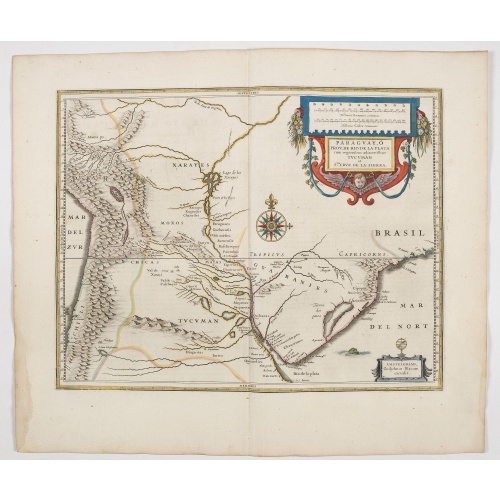
Paraguayo prov. de Rio de La Plata cum regionibus..
A beautiful map of Paraguay, and parts of Peru, Chile, Argentina, Brazil and Bolivia. Much of the area was still "Terra Incognita" so there are few towns and cities shown. The Andes are clearly shown to the west as well as the river systems.The Renaissance cartouche adds a special decorative accent to the map. The small cartouche in the lower right gives the name of the publisher. From early on Willem Jansz. Blaeu aimed of publishing an atlas to compete with the Hondius-Jansson Atlas. By 1630, ...
€600
Maker : BLAEU, W.
Place : Amsterdam
Date : 1644
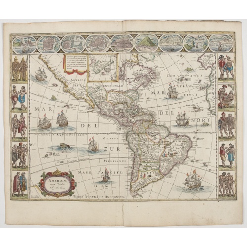
Americae Nova Tabula.
An inset shows Greenland and Iceland. Decorative elements include ships, sea monsters, and vignettes of native Americans within South America. In addition, the map is bordered by a series of nine maps and birds-eye views at the top (including Cusco, Havana, and Mexico City) and ten ethnographic views of various Native Americans.The delineation of the coast and the nomenclature on both the Pacific and Atlantic coasts are basically Spanish in origin and follow the maps of Ortelius and Wytfliet. To...
€6.500
Maker : BLAEU, W.
Place : Amsterdam
Date : 1644
-500x500.jpg)
Peru.
FIRST EDITION, FIRST ISSUE OF THIS MAP. Decorated with ships and monsters in the sea. Orientated with east at the top. With the signature of G. Blaeuw lower right corner. Shows the Pacific coast of South America from Ecuador (at the left-hand side) as far south as the Atacama desert in the northern reaches of Chile. "As early as 1520, Spanish settlers in Panama had heard tales of a powerful civilization rich in gold that lay to the south, and in 1522 an expedition was organized to find this land...
$900
Maker : BLAEU, W.
Place : Amsterdam
Date : 1644
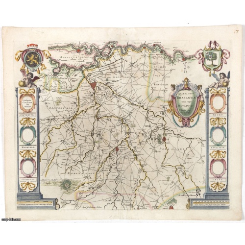
Quarta pars Brabantiae cujus caput Sylvaducis.
The coat of arms of Brabant and 's-Hertogenbosch do appear on the map. But the municipal arms in the columns on right and left-hand side have not yet been filled in. The map was prepared by Willibrordus van der Burgt.Considered one of the most decorative maps published by the publishing house of Blaeu.
$750
Maker : BLAEU, W.
Place : Amsterdam
Date : 1645
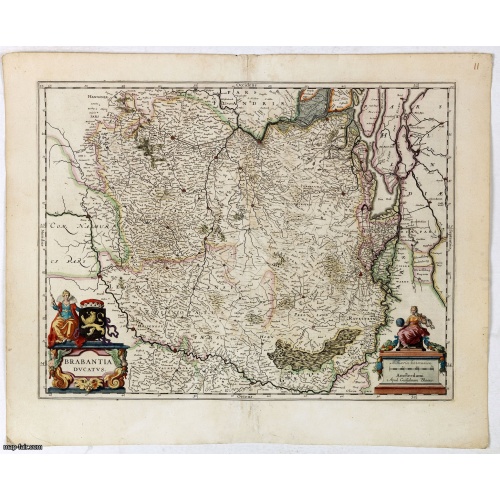
Brabantia Ducatus.
A very decorative map by Willem Blaeu with west is at the top. On the lower left a magnificent cartouche with a sitting female figure carrying a globe and compasses and the coat of arms of Brabant. The map encloses the area between the rivers Rhine, Meuse and Scheldt, with Namur (Namen) as the most southern town.
$400
Maker : BLAEU, W.
Place : Amsterdam, 1645
Date : 1645
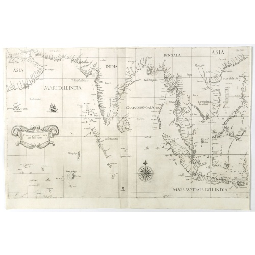
Carta prima Generale dell' Asia.
FIRST STATE of Robert Dudley's general chart of the Persian Gulf, going east through India to the southeastern coast of China showing Macau and the area of present-day Hong Kong. The map goes south through the Philippines, passing through Borneo, the western part of Celebes (now Sulawesi, Indonesia). It also includes the Maldives and the Chagos Archipelago.This elegant sea chart is crisply engraved in the sparse Florentine style with superb calligraphy throughout. Very decorative chart from the ...
$17.500
Maker : DUDLEY, R.
Place : Florence
Date : 1646
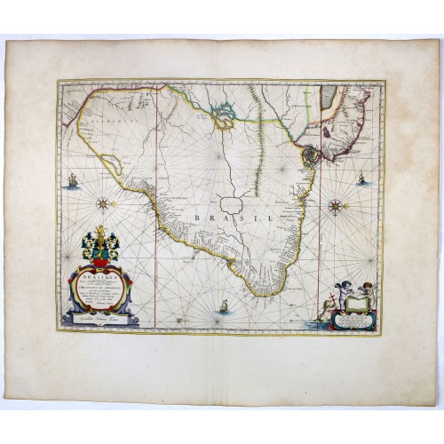
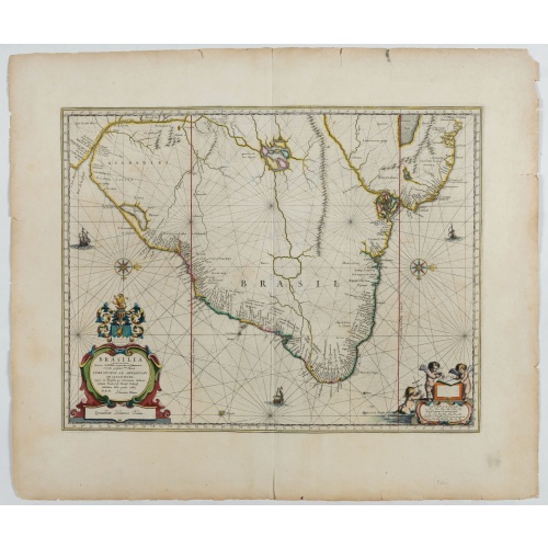
Brasilia.
Striking old color example of Blaeu's second map of Brazil prepared by Krystof Arciszewski, a Polish general who worked for the Dutch West Indian Company. The map perpetuates various myths, including the Parime Lago , although it is generally more accurate than its predecessors. The map includes the region from the mouth of the Amazon River to the La Plata. Orientated with west to the top. Including the mouth of the Amazon.Brasil was first discovered by Pedro Álvares Cabral in 1500 while en rou...
€750
Maker : BLAEU, J.
Place : Amsterdam, 1647
Date : 1647
Brasilia.
Fine copy of this map by Krystof Arciszewski, a Polish general who worked for the Dutch West Indian Company. The map perpetuates various myths including the Parime Lago , although it is generally more accurate than its predecessors. Orientated with west to the top. Including the mouth of the Amazon.
€700
Maker : BLAEU, J.
Place : Amsterdam
Date : 1647
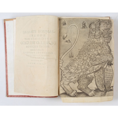
De Bello Belgico, Decas Prima / Decas Secunda.
With 2 engraved titles of the 'Leo Belgicus', with one paw resting on a shield bearing the title, large woodcut printer's device on the colophons, and 30 richly engraved views and plans of battles and sieges, 28 double-page and 2 full-page, by Johanness W.Bauer, J.Miele, Jacomo Cortese, a.o. Two examples of the famous Leo Belgicus map are included. Among the greatest decorative works of early cartography is a series of arresting maps showing The Netherlands and Belgium in the shape of a lion.Thi...
€6.900
Maker : STRADA, Famiano.
Place : Rome, Franciscus Corbelletus
Date : 1632-1647
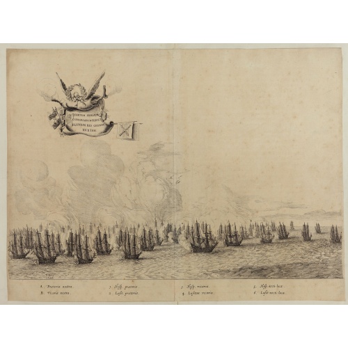
Quartum Praelium Coniovian inter et Fluvium Rio Grande XVII Ian
Decorative engraving of the fourth sea battle with the Portuguese fleet offshore at the Rio Grande, in 1640. Engraved by J. van Brosterhuyzen after a design by Frans J. Post (1612-1680). Below the engraving a numbered key (1-6). Signed in the plate "F. Post 1645" and decorative title cartouche, with "[Quartum praelium coniovian inter et fluvium Rio Grande XVII Jan" in the upper left corner.Taken from C. BARLAEUS, Rerum per octennium in Brasilia (...).
$450
Maker : POST, F. J.
Place : Joannes Blaeu, Amsterdam 1647
Date : 1647
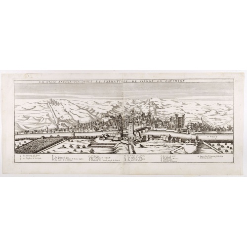
La ville archie-piscopale et primatiale de Vienne en Dauphiné.
View of Vienne, engraved by François de La Pointe.
€600
Maker : DE LA POINTE, F.
Place : Paris
Date : 1648
-500x500.jpg)
Currus Veliferi Illmi. Pr. Mauritii Nassouvii. (Prince Maurits' sailing-carriage, designed by Simon Stevin. )
Prince Maurits' sailing carriages had been designed by Simon Stevin. The Prince, always accessible to new inventions of his old instructor, could not please the foreign ambassadors more than by inviting them for a ride in his carriage. The big sailing-carriage could seat 28 persons and could reach a speed of seven miles per hour. Land sailing : The Chinese had "wind-driven carriages" since the 6th century AD, during the Liang Dynasty, and eventually mounted masts and sails on large wheelbarrows....
$1.800
Maker : BLAEU, J.
Place : Amsterdam
Date : 1649