
-500x500.jpg)
Virulus marinus. Cete (Whale and whaling scene)
Whale and whaling scene, set against a mountainous landscape in the manner of Pieter Brueghel the Elder. Plate number 1. The engraving is copied after Adrian Collaert plate in "Piscium Vivæ Icones" a series first published in Antwerp by Adriaen Collaert after 1598, later published between 1627 and 1677 by Galle family. Several copies were made of this series.Most of the ships in the background were copied from a series of ten prints known as the Sailing Vessels, executed by Frans Huys after des...
$300
Maker : COLLAERT, Adriaen (after)
Place : Antwerp
Date : after 1598
![[Lot of 6 maps / prints] Schets van de Donkere Baai in Nieuw Zeeland 1773.](/uploads/cache/86004-500x500.jpg)
[Lot of 6 maps / prints] Schets van de Donkere Baai in Nieuw Zeeland 1773.
A map of Dusky Bay, visited by James Cook in 1773. From a Dutch edition of ‘Cook's voyages'. Schets van de Donkere Baai in Nieuw Zeeland 1773. Nicolas Bellin's map of the Marianas islands with an inset map of Guam. A view of Easter Island, of men of Hapahee in a fighting contest and a plan of a Tahitian war proha. Together 6 maps / views of the Pacific Ocean.Captain James Cook (1728-79), explorer, circumnavigator and hydrographer. Three voyages, 1768-71, 1772-75 and 1776-79. From 1778 on p...
€350
Maker : James Cook
Place : London
Date : ca. 1790
-500x500.jpg)
Calendrier de la cour, tiré des éphémérides, pour l'Année bissextile.. / Notebook bearing silver plates with the VOC monogram.
A personal gift, only made for the trustees of the V.O.C. The silver plate was probably made by Drick van Hengel and Company because an entry in the diary of mintmaster Johann Georg Holtzhey for the years 1777-1784 reveals that silver work for book clasps for the Delft and Rotterdam chambers was to be supplied by Dirck van Hengel and Company on a yearly basis.The almanac contains a list of the daily sun rise and sun set, the phases of the moon, etc. Jacques Collombat (Grenoble, circa 1668 - idem...
$4.500
Maker : HÉRISSANT, Ve.
Place : Paris/Amsterdam
Date : 1787
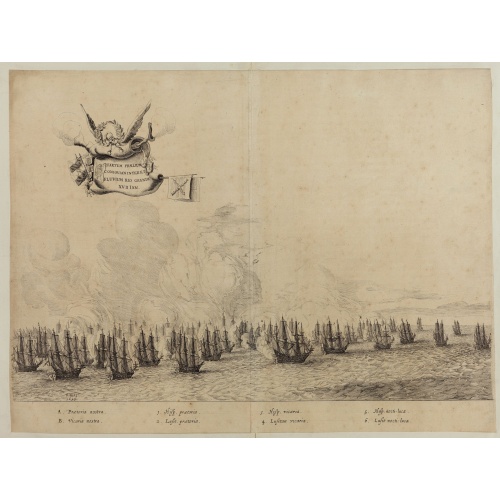
Quartum Praelium Coniovian inter et Fluvium Rio Grande XVII Ian
Decorative engraving of the fourth sea battle with the Portuguese fleet offshore at the Rio Grande, in 1640. Engraved by J. van Brosterhuyzen after a design by Frans J. Post (1612-1680). Below the engraving a numbered key (1-6). Signed in the plate "F. Post 1645" and decorative title cartouche, with "[Quartum praelium coniovian inter et fluvium Rio Grande XVII Jan" in the upper left corner.Taken from C. BARLAEUS, Rerum per octennium in Brasilia (...).
$450
Maker : POST, F. J.
Place : Joannes Blaeu, Amsterdam 1647
Date : 1647
![[A Lot of 2 maps Europe]](/uploads/cache/86277-500x500.jpg)
[A Lot of 2 maps Europe]
Claude Buy de Mornas (d. 1783), géographe du roi (1764). Atlas Méthodique et Elémentaire de Géographie et d' Histoire, 1761, Atlas Historique et Géographique, 1762. A map showing the European continent. With on both sides a descriptionary text. All within an elaborate and very decorative border. A very fine item. Plus a map of Europe from Victor LeVasseur's Atlas, the last atlas with decorative maps.A lot of 2 maps Europe
€300
Maker : BUY DE MORNAS, Cl.
Place : Paris
Date : 1762
![[Lot of 13 prints of the Chinese court] Habillement de l' Empereur dela Chine & des Dames de son Palais aves quel...](/uploads/cache/IMG_08451-500x500.jpg)
[Lot of 13 prints of the Chinese court] Habillement de l' Empereur dela Chine & des Dames de son Palais aves quel...
Prints of the Chinese court.[Lot of 13 prints]- Salle Imperiale De L'Audience, tiree de Nieuhof (1760)- Pagodes ou Statues; Miniso ou la Volupté (1749- Pagodes ou statues du temple. 1. Un defenseur de la patrie.- Mandians vacabonds / Autres mandais - Pagodes ou statues du temple- Salle Imperiale de l'Audience tiree de Nieuhof- Laboureurs (1750)- Cour du Grand Mogol- l'ambassadeur conduit a l’audience- Le Grand Throne Imperial.- Mandians Vagabonds. Autres Mandians / Zwervende Schooije...
€400
Maker : BELLIN, J.N.
Place : Amsterdam
Date : 1750
![[Lot of 17 maps] L' ISLE DE FRANCE Pariensis agri descriptio. Francois de la Hoeye fecit, Jean le Clerc excud.](/uploads/cache/86212-500x500.jpg)
[Lot of 17 maps] L' ISLE DE FRANCE Pariensis agri descriptio. Francois de la Hoeye fecit, Jean le Clerc excud.
The map of Ile de France which Jean Leclerc added in his re-issue of Maurice Bouguereau's atlas 'Theatre Francois' , as ' La Theatre geographique de France' in 1619. An uncommon and decorative map.[Lot of 17] maps of F R A N C E- L'Isle de France, Parisiensis agri descrip(tio). - Gouvernemens de Picardie, de Boulonnois, et d’Artois (1768)- V. Descrittione del Regno della Gallia (1598)-La France Divisée en ses quarante Gouvernamens Généraux et Militaire.- - Topographia aug. Turon. duca...
€1.000
Maker : Jean Leclerc
Place : Paris
Date : 1619
![[ Lot of 2 maps of the Asian continent]Asia Divisa in Imperia, Regna & Status in que distribuitur, ad usum serenissimi Burgundiae Ducis](/uploads/cache/86164-500x500.jpg)
[ Lot of 2 maps of the Asian continent]Asia Divisa in Imperia, Regna & Status in que distribuitur, ad usum serenissimi Burgundiae Ducis
Fine map of the Asian continent published in Amsterdam by R. and J. Ottens, after H. Jaillot.Together with a map by Claude Buy de Mornas (d. 1783), géographe du Roi (1764). He published Atlas Méthodique et Elémentaire de Géographie et d' Histoire, 1761, Atlas Historique et Géographique, in 1762. All within an elaborate and very decorative border. A very fine item.[Lot of 2 maps] of the Asian continent.-Asie-Asia Divisa in Imperia, Regna & Status in que distribuitur, ad usum serenissimi Bu...
€400
Maker : OTTENS, R. and J. / Buy de Mornas, Cl.
Place : Amsterdam
Date : 1740
![[Lot of 14 maps of Germany] Nova Totius Germaniae Descriptio.](/uploads/cache/86021-500x500.jpg)
[Lot of 14 maps of Germany] Nova Totius Germaniae Descriptio.
Willem Blaeu, founder of the famous publishing firm. Originally publishing pilot-guides, he issued his first atlas, 'Atlantis Appendix', in 1630, followed by his "Theatrum Orbis Terrarum" or "Novus Atlas" in 1635.Willem Blaeu's map of Germany. From the French edition of Willem Blaeu's atlas "Theatrum". With 13 other map of general Germany by Tirion, Bachienne and Bonne.[Lot of 14 maps]- Nova Totius Germaniae Descriptio. Blaeu 1634- Nieuwe kaart van Duitsland verdeelt in zyn Thien Kre...
€500
Maker : BLAEU, W.
Place : Amsterdam
Date : 1635
![[Set of 2 maps of Caspian Sea.] Carte marine de la Mer Caspiene. Levee suivant les ordres de S.M. Czariene, P](/uploads/cache/86020-(1)-500x500.jpg)
[Set of 2 maps of Caspian Sea.] Carte marine de la Mer Caspiene. Levee suivant les ordres de S.M. Czariene, P
Guillaume de l' Isle (1675-1724), Royal Geographer, was the most influential cartographer of the first quarter of the 18th century. ' Atlas de Géographie' (1700-12), posthumous ' Atlas Nouveau' (1730). After the death of the widow of Pieter Mortier in 1719, the firm continued till 1778 as Covens & Mortier. They published numerous atlases and pocket atlases, using maps after de l' Isle and Jaillot.Two charts together depicting the Caspian Sea; the northern part of the Caspian Sea with insets dep...
€350
Maker : Guillaume Delisle
Place : Paris
Date : 1721
![[Lot of 8 maps of European Russia] Partie Septentrionale de la Russie Europeenne ou sont distinguees exactement toutes les Provinces](/uploads/cache/86005-500x500.jpg)
[Lot of 8 maps of European Russia] Partie Septentrionale de la Russie Europeenne ou sont distinguees exactement toutes les Provinces
[Lot of 8 maps of European Russia]- Partie Septentrionale de la Russie Européenne òu sont distinguées exactement toutes les Provinces (1753)- Carte des Pais Habites par les Samojedes et Ostiacs (1757)- 2x Carte de la Partie Septentrionale de la Russie Européenne- Partie Septentrionale de la Russie Europeenne ou sont distinguees exactement toutes les Provinces (1753)- Nouvelle Carte des Etats du Grand duc de Moscovite en Europe (1714)- Partie Meridionale de Moscovie Dressee Par G. de L’...
€600
Maker : BELLIN, Jacques Nicolas
Place : Paris
Date : 1757
![[Lot of 10 maps] Carte Nouvelle de la Grande Tartary.](/uploads/cache/85969-500x500.jpg)
[Lot of 10 maps] Carte Nouvelle de la Grande Tartary.
Antique map of Asian Russia] Carte Nouvelle de la Grande Tartarie ou de l'Empire du Grand Cham. With 10 maps / views of Asian Russia- Carte Nouvelle de la Grande Tartarie ou de L’empire du Grand Cham (1719)- Baie de castries settee sur la cote orientale de tartarie (1797)- Carte du Kamtchatka Dressee et Gravée par Laurent (1757)- 2x Gezichten der kust van Asiën.- Gezichten der kust van Kamtchatka.- Carte de la Tartarie Occidentale, Pour servir à l'Histoire Générale (1749)- IImperium Rus...
€700
Maker : CHATELAIN, H.
Place : Amsterdam
Date : 1720 - 1730
-500x500.jpg)
Geographie Universelle dite de Crozat.
A nice geographical dictionair with maps of the world and the continents and maps of European countries. Lacks the maps of France and of the Turkish empire.
€280
Maker : Crozat.
Place : Paris
Date : 1823
Nieuwe Pascaert van de Kust van Maroca en Zanhaga. . .
A very fine sea chart of the west coast of Morocco between C.Cantin tot C.Bajador and the Canary Islands, Lanzerote and Fuerteventura. With a very large decorative title-cartouche and an inset depicting Porto de Nao en Po. de Cavallos on Lanzerote. Rhumb lines. Johannes van Keulen is the founder of the successful van Keulen firm that published charts, pilot guides and sea-atlases for over 2 centuries. In 1680, he published his immensely popular 'Zee Atlas of te Water Werelt'.
€600
Maker : VAN KEULEN, Johannes.
Place : Amsterdam
Date : ca 1685
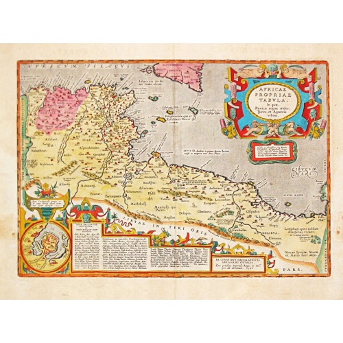
AFRICAE PROPRIAE TABULA In qua, Punica regna vides; Tyrios, et Agenoris / urbem.
AFRICAE PROPRIAE TABULA In qua, Punica regna vides; Tyrios, et Agenoris / urbem. Antique map of North Africa with Carthage. A very decorative map of North Africa with an inset with the town of Carthage. From the rare Spanish edition of Abraham Ortelius’ ‘Theatrum Orbis Terrarum’, published by Vrientius. Abraham Ortelius(1527-98), Dutch cartographer and publisher of the first modern atlas, ' Theatrum Orbis Terrarum' in 1570. Editions till 1612. Also an atlas of ancient cartography, the '...
€350
Maker : ORTELIUS, A.
Place : Antwerp
Date : 1590
![[Dutch provo Propaganda Poster] De Vrije Maagd Radio](/uploads/cache/86256-500x500.jpg)
[Dutch provo Propaganda Poster] De Vrije Maagd Radio
Published in 1969, the year of the student unrest in Europe.Het jaar van de studenten opstanden in Europese landen! DUTCH PROVO POSTERAmsterdammers, luister niet naar de met het kapitaal Kollaborerende Hilversumse radio, maar naar de vrije maagd: 225 mtr middengolfkom naar het Spui beleger de belegeraars !
€200
Maker : Rob Stolk en H. Langhout
Place : Amsterdam
Date : 1969
![[Original drawing: Fisher's ships on the beach of Scheveningen.]](/uploads/cache/86253-500x500.jpg)
[Original drawing: Fisher's ships on the beach of Scheveningen.]
Unique pencil drawing: Typical Dutch beach life with flat-bottomed ships on the beach of Scheveningen. Signed in the lower right corner and on the back site with P.A. Beretta (Petrus Augustus Beretta)
€450
Maker : BERETTA, Petrus Augustus Artist
Place : The Netherlands
Date : c. 1850
-500x500.jpg)
Etats-Unis de l'Amérique du nord.
Detailed map of North America, prepared by Charles V. Monin (fl.1830-1880) a French cartographer of Caen and Paris. Published in Atlas Universel de Géographie Ancienne &c Moderne en 42 Cartes dressé par C.V. Monin. Engraved by Laguillermie.
$75
Maker : MONIN, C.V.
Place : Paris
Date : 1845

Pas kaart Van Rio Oronoque Golfo De Paria met d'Eylanden Trinidad, Tabago, Granada, Granadillos, en Bequia . . .
A highly detailed and rare sea chart of the mouth of the Orinoco River, Trinidad, Tabago, St.Vincent and neighboring islands. Oriented with north to the right by two compass roses.A large inset shows Tobago on a larger scale. Taken from De Nieuwe Groote Lichtende Zee-Fakkel, Part IV.Decorative scale cartouche features Neptune with his entourage and natives with trade goods. The chart is further adorned with a monkey atop the title cartouche and a sailing ship.
$900
Maker : VAN KEULEN, J.
Place : Amsterdam
Date : 1684
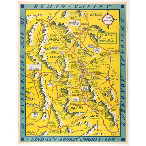
A Hysterical Map Of Death Valley National Monument -- And It's Looking Mighty Low
First edition Humorous map of Death Valley. "Drawn In Broken English by Jolly Lindgren," this comic pictorial map is full of puns and comic vignettes related to Death Valley. The Lindgren Brothers issued a number of other silly whimsical maps of national parks and other parts of the West.
$500
Maker : LINDGREN, J.
Place : Spokane, Wash., Lindgren Brothers,
Date : 1948