
![[Lot of 5 maps] Kaart van de noord-west kust van Amerika en de noord-oost kust van Asia.](/assets/images/image-loading.svg)
[Lot of 5 maps] Kaart van de noord-west kust van Amerika en de noord-oost kust van Asia.
- Kaart van de noord-west kust van Amerika en de noord-oost kust van Asia. Opgenoomen in de Jaaren 1778 en 1779.Captain James Cook (1728-79), explorer, circumnavigator and hydrographer. Three voyages, 1768-71, 1772-75 and 1776-79. From 1778 on printed editions of ' Captain Cook's Travels' appeared in English, Italian, French and Dutch east coast. From a Dutch edition of Cook's voyages'.- Carte d'une Partie DE L'AMERIQUE SEPTRIONALE qui comprendles POSSESSIONA ANGLAISES. This map depicts colonia...
€300
Maker : COOK, J.
Place : Leiden
Date : 1795-1803
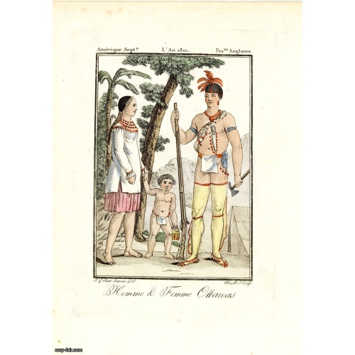
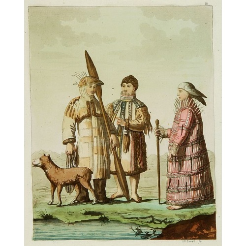
Homme & Femme Ottawas.
Hand-colored mezzotint of Native Americans engraved by Félix Mixelle and Lachaussée Jeune after Jacques Grasset de Saint-Sauveur.As an etcher, drawer and writer, Grasset de Saint-Sauveur was a prolific polygraph in keeping with the encyclopedic spirit of the eighteenth century: he wrote exotic novels as well as documentary works on various subjects. Called by one of his biographers a drawer without genius but a good example of the taste of his time, Grasset de Saint-Sauveur was literally bewit...
$75
Maker : GRASSET DE SAINT SAUVEUR,J.
Place : Paris,
Date : 1806
![A Map of the United States and Canada, New-Scotland, New-Brunswick and New-Foundland ... [together with] A Map of the West-Indies and of the Mexican-Gulph...](/uploads/cache/39235-500x500.jpg)
A Map of the United States and Canada, New-Scotland, New-Brunswick and New-Foundland ... [together with] A Map of the West-Indies and of the Mexican-Gulph...
A Map of the United States and Canada, New-Scotland, New-Brunswick and New-Foundland / Carte des Etats Unis, avec Le Canada, la Nouvelle Ecosse, le Nouveau Brunswick & Terre-Neuve. Dressée par LAPIE, Capitaine-Ingénieur-Géographe. Publiée par P.A.F.TARDIEU, Graveur, Editeur propriétaire a Paris. Déposée à la Bibliothèque Imperiale, le 10 Juin 1806. [together with]A Map of the West-Indies and of the Mexican-Gulph / Carte des Indes Occidentales et du Golfe du Mexique. Dressée par LAPIE, ...
€5.000
Maker : P.A.F. TARDIEU
Place : Paris
Date : 1806
L'Amérique Méridionale, Divisée en ses Principaux Etats.
Map of South America, from Atlas de la Géographie de toutes les parties du monde .. Ouvrage destiné pour l'education, et nécessaire aux négocians, aux voyageurs, aux fonctionnaires publics, aux banquiers, aux agens de change, aux littérateurs, etc..
€60
Maker : DELAPORTE, L'Abbé.
Place : Paris, Prudhomme, Levrault, Debray
Date : 1806
Carte du royaume de France divisé en 87 départemens / dressée par Brion de la Tour..., où sont tracées les nouvelles limites fixées par le traité de paix du 30 mai 1814. . .
Very decorative and uncommon map of France, with Corsica prepared by Brion de la Tour showing the new border set by the Peace Treaty of May 30, 1814. Engraved by Chaumier. The map is bordered by French Kings up to Louis XVIII.The Treaty of Paris was made between representatives of the allies and France following the restoration of Louis XVIII. The terms towards France were relatively lenient to assist the Bourbon restoration, although provisions were made for a strengthening of the states border...
€750
Maker : DESNOS/ BRION DE LA TOUR.
Place : Paris
Date : ca. 1814
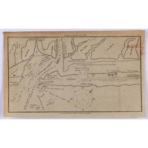
Little Egg Harbour.
A small sea chart showing Little Egg Harbour east of Tucker's Island. This map was published in the “American Coast Pilot”, a detailed guide to harbors, capes and headlands on the east coasts of North and South America. It includes information on winds, currents, tides as well as latitudes and longitudes. The American Coast Pilot was published between 1796 and 1861, until it was replaced by the US Coast Survey.Edmund March Blunt (1770–1862) was an American navigator, author, and publisher ...
$50
Maker : BLUNT, E.
Place : New York, 1817
Date : 1817
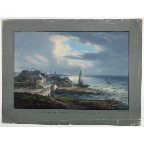
Vue de Gattweick et de l'embouchure du Rhin, dans la Mer du Nord.
Very decorative view of Katwijk. Signed lower right, Louis Bleuler au chateau de Laufen . Original design by Louis Bleuer. This gouache was the model for his aquatint in his famous book 80 Rheingegenden published in 1826.
$1.500
Maker : BLEULER, L.
Place : gERMANY
Date : 1820
Gedeelte van den Vereenigden Staat van Noord Amerika.
A rare an detailed map of the eastern part of the United States of America. After Isaac Weld's map from his Travels through the States of North America 1799. Barbara Backus McCorkle does mention English, French and German editions, but not this Dutch text edition. (See map 800.4 for a German text variant)Lower right hand corner inset map of South Carolina.
€750
Maker : ANONYMOUS
Place : Netherlands c. 1820
Date : 1820
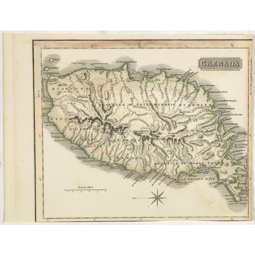
Grenada.
A delightfully detailed map the West Indian island Grenada by John Thomson. The map displays excellent detail concerning roads, rivers, towns, bays, harbours and other interesting topographical details.Thomson (1777-c1840) was a Scottish cartographer from Edinburgh, celebrated for his 1817 New General Atlas, published by himself in Edinburgh, John Cumming in Dublin, and Baldwin, Cradock, and Joy in London.
$50
Maker : THOMSON, J.
Place : Edenburgh
Date : 1821
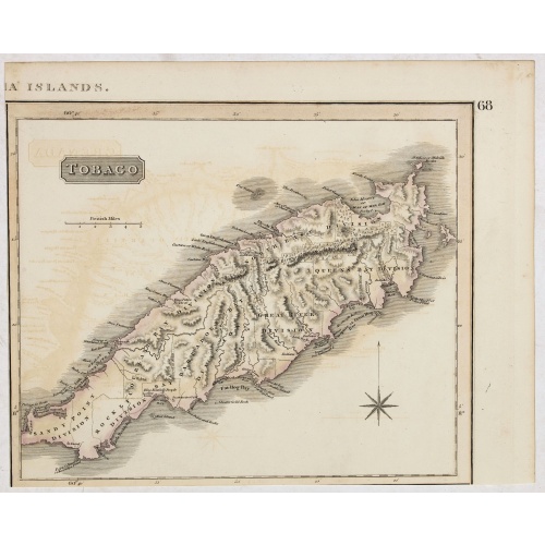
Tobago.
A delightfully detailed map of the West Indian island Tobago by John Thomson. The map displays excellent detail concerning roads, rivers, towns, bays, harbors, and other interesting topographical details.Thomson (1777-c1840) was a Scottish cartographer from Edinburgh, celebrated for his 1817 New General Atlas, published by himself in Edinburgh, John Cumming in Dublin, and Baldwin, Cradock, and Joy in London.
$50
Maker : THOMSON, J.
Place : Edenburgh
Date : 1821
-500x500.jpg)
Geographie Universelle dite de Crozat.
A nice geographical dictionair with maps of the world and the continents and maps of European countries. Lacks the maps of France and of the Turkish empire.
€280
Maker : Crozat.
Place : Paris
Date : 1823

Eastern passage to China. sheet 1.
James Horsburgh early chart of the coasts of Java, Bali, Lombok, with part of Sulawesi, and Borneo. Insets of "Sketch of Bally Strait", Sketch of Lombock Strait", Plan of Allas Strait", "Sketch of Sappy Strait".The chart shows depth soundings & both topographical and hydrographical details and proposed sailing directions in the Sunda Straits. Filled with several coastal profiles, which were of great help for the sailor.In top Horsburgh thanks for the aid he has gotten for preparing this chart : ...
$3.000
Maker : HORSBURGH, JAMES, F.R.S
Place : London
Date : 1824
Portrait de Benjamin Franklin.
Portrait de Benjamin Franklin. From Giulio Ferrario's work Le Costume ancien et moderne ou histoire du gouvernement, de la milice, de la religion, des arts, etc. published in Milan by the author between 1816 and 1827.This aquatint engraved plate was color printed on fine wove paper of a soft aged white color, bearing the embossed seal of authenticity impressed at the time of publication with the legend “Il Costume Antico E Moderno” surrounding the initials GF. A beautifully hand colored aq...
$75
Maker : FERRARIO, G.
Place : Milan, 1827
Date : 1827
Les Aleuts.
From Giulio Ferrario's work Le Costume ancien et moderne ou histoire du gouvernement, de la milice, de la religion, des arts, etc. published in Milan by the author between 1816 and 1827.This aquatint engraved plate was color printed on fine wove paper of a soft aged white color, bearing the embossed seal of authenticity impressed at the time of publication with the legend "Il Costume Antico E Moderno" surrounding the initials GF. A beautifully hand colored aquatint with additional hand-coloring....
€50
Maker : FERRARIO, G.
Place : Milan
Date : 1827
[Lot of 7 Flower prints] Talauma mutabilis. flower Talauma mutabilis from 'FLORA MALESIANA' Arckenhausen del. / Hutz Lith.
The flower Talauma mutabilis from 'FLORA MALESIANA'. Talauma mutabilis by Karl Ludwig von Blume (9 June 1796, Braunschweig – 3 February 1862, Leiden) was a German-Dutch botanist. (3454)Lot of 7 flower prints.- Talauma mutabilis - Sobralia Macrantha- Détails de la liane femelle du Chili- Liane femelle du Chili- Détails de la lianne màle du Chili- Dianthus sinensis heddewigii- Dianthus sinensis laciniatus
€300
Maker : BLUME, Carl Ludwig. von
Place : Germany
Date : 1829
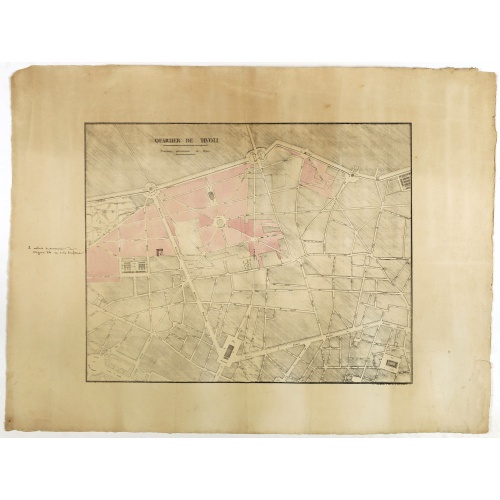
Quartier de Tivoli Nouveaux pereements de Rues.
Plan of the center of Paris showing Tivoli district with Madalene and Clichy. Lithography and pen and ink. Drawn in are the planned workshop of Serrurerie Théophile Mignon, 30 rue de la Bienfaisance.
€75
Maker : ANNONYMOUS
Place : Paris
Date : ca.1835

Carta esférica del Rio de la Plata : desde su embocadura hasta Buenos Aires.
Large nautical chart illustrating the estuary formed by the combination of the Uruguay River and the Paraná River. It forms part of the border between Argentina and Uruguay, with the major ports and capital cities of Buenos Aires in the southwest and Montevideo in the northeast.
$750
Maker : DIRECTION HIDROGRAFICA
Place : Madrid
Date : 1812-1838
-500x500.jpg)
Holland & Belgium.
An attractive steel engraved map of Holland and Belgium. Map flanked by France and Prussia. Duchy of Luxembourg included. Many place names and physical features shown. 4 mileage scales given.The Arrowsmith family members were among the most respected and influential cartographers of the nineteenth century. Taken from 'The London Atlas of Universal Geography…' John Arrowsmith (1790-1873) joined his uncle, Aaron Arrowsmith in mapmaking in London in 1810. Upon the death of his uncle in 1823, the ...
$110
Maker : ARROWSMITH, John
Place : London, 1839
Date : 1839
Regno de' Paesi-Bassi compresa la Olanda . . . / La Svizzera . . .
Two rare and detailed maps of The Netherland (210 x 230mm. ) and Switzerland (140 x 230mm.) According to the title cartouche, prepared by J.A.Buchon and A de La Sage for l'Atlante Storico, Letterario, Biografico, Archeologico. . . with attributions by Giambatista Albrizzi.Lower left a color-key, giving good detail and information. We were not able to find references to the publisher, engraver or author of this map. Uncommon and in very good condition.
$60
Maker : TASSO, G.
Place : Venice, 1840
Date : 1840
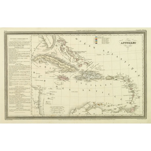
Antilles.
Finely engraved map of the Caribbean, with a color key to Spanish, English, French, Danish, Dutch and Swedish possessions, prepared by A.H.Dufour and engraved by Giraldon-Bovinet. Published by Jules Renouard in his uncommon atlas "Le globe Atlas classique Universel de géographie ancienne et moderne, pour servir a l'étude de la géographie et de l'histoire dressé par M. A.H.Dufour, Et revu par M.Jomard".To the left- "Tableau statistique", giving details on geographical, statistical and economi...
€75
Maker : DUFOUR, A.H.
Place : Paris, Jules Renouard
Date : ca. 1840