
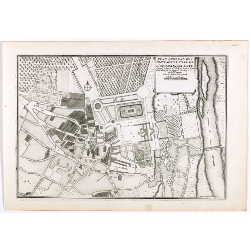
Plan general des chateaux et ville de St Germain en Laye.
City plan of St Germain en Laye, from Nicolas de Fer's "L'Atlas curieux ou le Monde réprésente dans des cartes. "The "Atlas Curieux" is a geographic encyclopedia of images and a celebration of the French Empire under the Sun King, with maps of French possessions in the western hemisphere, maps of France, with detailed views of the grand waterworks at Marly, views of the great palaces and chateaux, views and plans of the Paris Observatory, and samples of military architecture. Issued in six ann...
€60
Maker : DE FER, N.
Place : Paris
Date : 1705
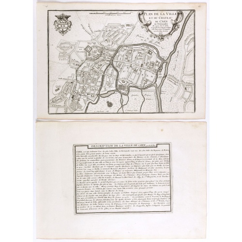
Plan de la ville et du château de Caën en Normandie.
Plan of the city of Caen, from Nicolas de Fer's "L'Atlas curieux ou le Monde réprésente dans des cartes. "The "Atlas Curieux" is a geographic encyclopedia of images and a celebration of the French Empire under the Sun King, with maps of French possessions in the western hemisphere, maps of France, with detailed views of the grand waterworks at Marly, views of the great palaces and chateaux, views and plans of the Paris Observatory, and samples of military architecture. Issued in six annual par...
€60
Maker : DE FER, N.
Place : Paris, 1705
Date : 1705
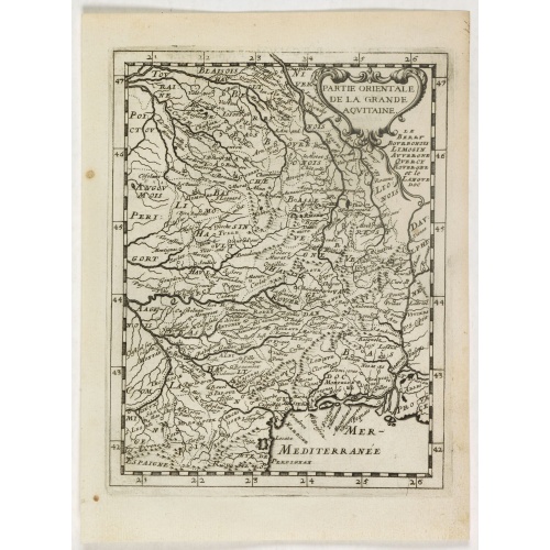
La partie orientale de la Grande Aquitaine.
Map taken from "Geographique Theater de l'Europe …, a rare work by the Jesuit priest Briet.
€50
Maker : BRIET, Ph.
Place : Paris
Date : 1649
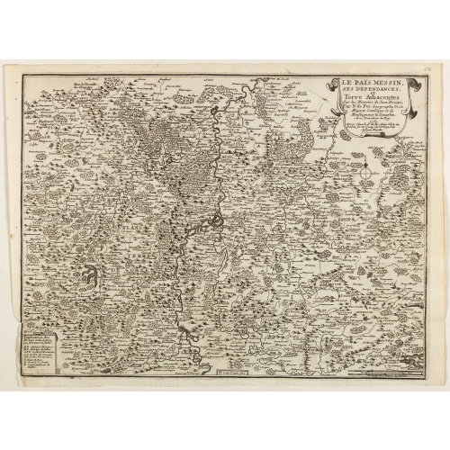
Le Païs Messin, ses dependances, et Terre Adiacentes.
Map of the Messin region, from Nicolas de Fer's "L'Atlas curieux ou le Monde réprésente dans des cartes. "The "Atlas Curieux" is a geographic encyclopedia of images and a celebration of the French Empire under the Sun King, with maps of French possessions in the western hemisphere, maps of France, with detailed views of the grand waterworks at Marly, views of the great palaces and chateaux, views and plans of the Paris Observatory, and samples of military architecture. Issued in six annual par...
€60
Maker : DE FER, N.
Place : Paris
Date : 1705
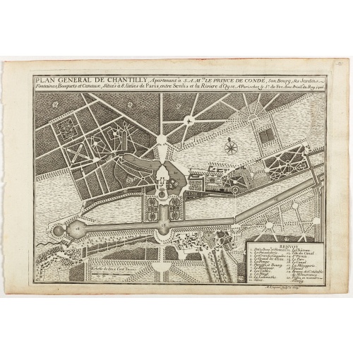
Plan general de Chantilly . . .
Plan of the city of Chantilly, from Nicolas de Fer's "L'Atlas curieux ou le Monde réprésente dans des cartes. "The "Atlas Curieux" is a geographic encyclopedia of images and a celebration of the French Empire under the Sun King, with maps of French possessions in the western hemisphere, maps of France, with detailed views of the grand waterworks at Marly, views of the great palaces and chateaux, views and plans of the Paris Observatory, and samples of military architecture. Issued in six annua...
€60
Maker : DE FER, N.
Place : Paris
Date : 1705
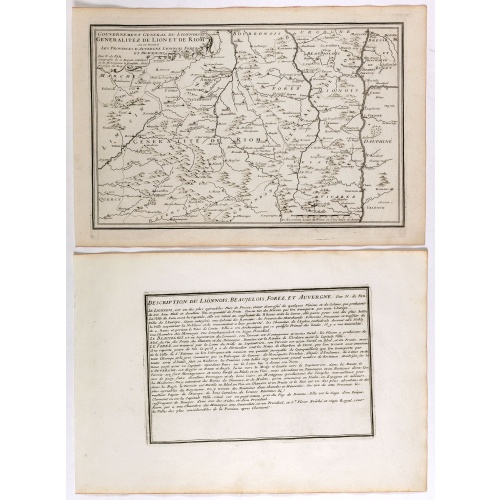
Gouvernement general du Lionnois, generalitez de Lion et de Riom . . .
Map of central France with Clermont-Ferrand and Lyon to the right, from Nicolas de Fer's "L'Atlas curieux ou le Monde réprésente dans des cartes. "The "Atlas Curieux" is a geographic encyclopedia of images and a celebration of the French Empire under the Sun King, with maps of French possessions in the western hemisphere, maps of France, with detailed views of the grand waterworks at Marly, views of the great palaces and chateaux, views and plans of the Paris Observatory, and samples of milita...
€60
Maker : DE FER, N.
Place : Paris
Date : 1705
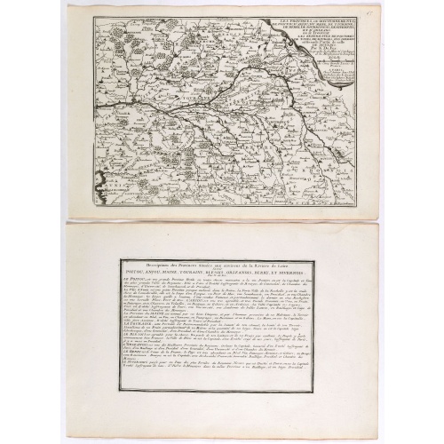
Les Provinces, ou Gouvernement de Poictou, d'Anjou, du Maine, De Touraine . . .
Map centered on Loire region, with Blois, Saumur, Sancerre and Orleans, from Nicolas de Fer's "L'Atlas curieux ou le Monde réprésente dans des cartes. "The "Atlas Curieux" is a geographic encyclopedia of images and a celebration of the French Empire under the Sun King, with maps of French possessions in the western hemisphere, maps of France, with detailed views of the grand waterworks at Marly, views of the great palaces and chateaux, views and plans of the Paris Observatory, and samples of m...
€80
Maker : DE FER, N.
Place : Paris
Date : 1705
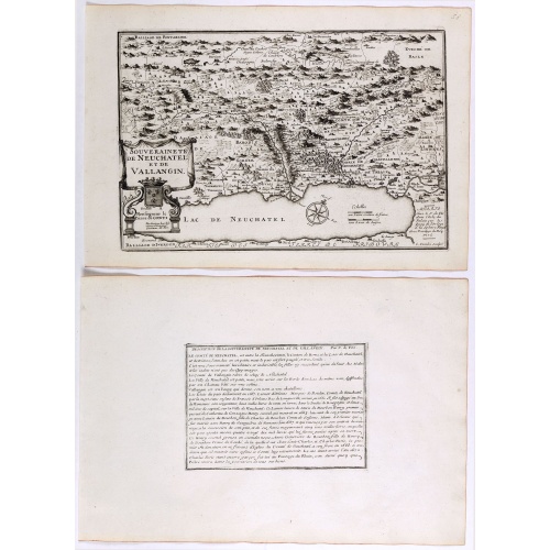
Souveraineté de Neuchatel et de Vallangin.
Map of the Neuchatel region, from Nicolas de Fer's "L'Atlas curieux ou le Monde réprésente dans des cartes. "The "Atlas Curieux" is a geographic encyclopedia of images and a celebration of the French Empire under the Sun King, with maps of French possessions in the western hemisphere, maps of France, with detailed views of the grand waterworks at Marly, views of the great palaces and chateaux, views and plans of the Paris Observatory, and samples of military architecture. Issued in six annual ...
€60
Maker : DE FER, N.
Place : Paris
Date : 1705
![[John Smith caught by the French.]](/uploads/cache/40473-500x500.jpg)
[John Smith caught by the French.]
In 1615, during one of John Smith’s voyages across the Atlantic, he was caught by some French pirates. While at sea in captivity he was forced to suffer great hardships but, one night during a storm in the Bay of Biscay when the crew were forced below deck, he managed to escape in a rowing boat. All night he was tossed about by the waves with only a pike to help him steer. The small boat was eventually driven ashore on the island of Charante where some bird-catchers found him almost dead from ...
€75
Maker : GOTTFRIED, J.L. / DE BRY.
Place : Frankfurt, M.Merian
Date : 1633
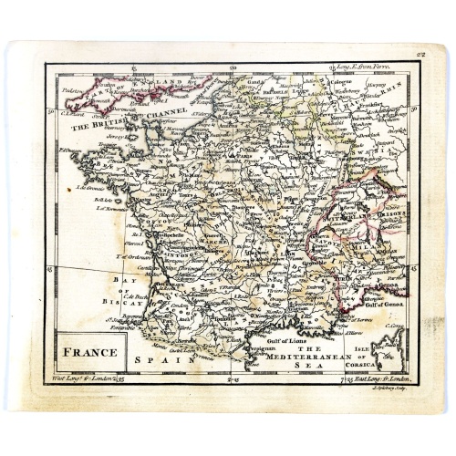
France.
Uncommon miniature map of France, engraved by J.Spilbury for "A New General and Universal Atlas Containing Forty five Maps by Andrew Dury".This miniature atlas published during the Seven Years' War.The maps are typical for the period and well executed with great clarity. The plates are engraved in 1761 and in 1763 a second edition was presumably produced for the French market having all but nine with a French titles added above the top.
€50
Maker : DURY, A. / SAYER, R. / KITCHIN, T.
Place : London
Date : 1761-1763
![Carte generale de France. [de l'Europe]](/uploads/cache/38442-500x500.jpg)
Carte generale de France. [de l'Europe]
A fine and uncommon early 17th century map of France printed from two copper plates. Engraved by Liébaux.From the French text edition of "Description d'Univers", 1683. by Allain Manneson Mallet (1630-1706), a well travelled military engineer and geographer who worked in 17th century France under King Louis XIV.
€80
Maker : MALLET, A.M.
Place : Paris
Date : 1683
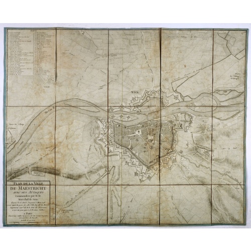
Plan de la ville de Maestricht avec ses attaques commandées par M. le maréchal de Saxe, depuis le 15 avril jusqu'au 3 may 1748 . . .
A plan of Maastricht rising after the capture of the city by the French troops led by the Marshal of Saxony. The city was besieged between 15 April and 3 May 1748, during the War of Succession of Austria.With numbered key (1-53).
$600
Maker : JAILLOT, J.
Place : Paris
Date : 1781
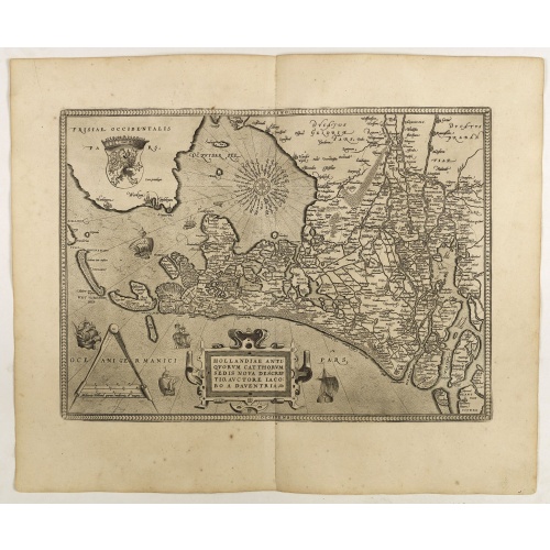
Hollandiae Antiquorum Catthorum..
This map shows Holland in great detail, including small towns, walled cities, rivers and lakes (many of which were reclaimed in the 17th century, and no longer exist). A coat of arms is in the upper left corner of the map image. In the ocean, there are many sailing ships and smaller fishing boats. An intricate compass rose is in the upper middle area. A very decorative map of the Dutch provinces of Friesland, Groningen and Drente and of the German Province of Friesland.
$750
Maker : ORTELIUS, A.
Place : Antwerp
Date : 1598
![[Ternate].](/uploads/cache/37954-500x500.jpg)
[Ternate].
Text engraving showing a bay on the Island of Ternate, an island in the Maluku Islands (Moluccas) of eastern Indonesia. Above the map a lettered key (A-E). Text engraving from "Premier livre de l'histoire de la navigation aux Indes Orientales, par les hollandois, et des choses a eux advenues . . . ", being the classic account of the first Dutch voyage to the East Indies under the command of Cornelis de Houtman. the expedition left in 1595, after Holland had achieved independence from Spain and c...
$150
Maker : LODEWYCKSZ, Willem
Place : Amsterdam, Cornille Nicolas
Date : 1609
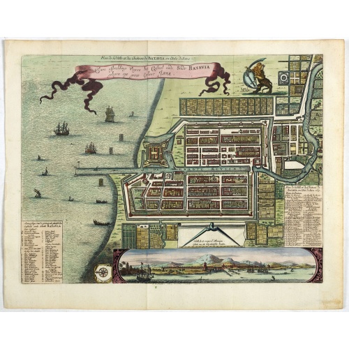
Ware affbeeldinge wegens het casteel ende stadt Batavia. . .
A reduced version of Clement de Jonghe (1650) plan of Jakarta from 1650. The town plan has a vignette at the bottom showing Jakarta from the sea with the volcanoes Mount Gede, Mount Pangrnago and Mount Salak in the background. Engraved for Arnoldus Montanus "Gedenkwaerdige gesantschappen der Oost-Indische maatschappy in ’t Vereenigde Nederland. . ." (1669) but reissued by Pieter van der AA.Batavia, present-day Jakarta, the Dutch center of trading activities in the East Indies. European and nat...
$800
Maker : VANDER AA, P.
Place : Leiden
Date : 1719
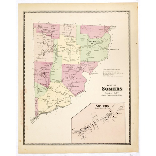
Town of Somers.
Fine lithographed map of the town of Somers. The map provides the names of specific homeowners, as well as information about the occupations and physical locations of the various tradesmen in each village from Beer's famous county atlas "Atlas of New York and vicinity," "a documentary record of nineteenth-century life and delightful specimens of American folk art." F. W. Beers, along with other members of his family, were among the leading county atlas publishers in the period immediately follo...
$90
Maker : DE BEERS, F.W.
Place : New York
Date : 1867
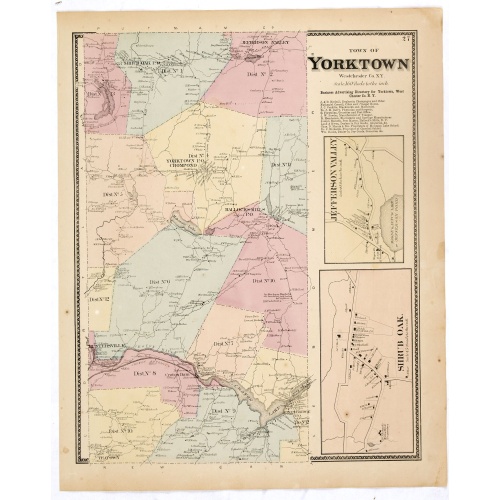
Town of Yorktown.
Fine lithographed map of the town of Yorktown. The map provides the names of specific homeowners, as well as information about the occupations and physical locations of the various tradesmen in each village from Beer's famous county atlas "Atlas of New York and vicinity," "a documentary record of nineteenth-century life and delightful specimens of American folk art." F. W. Beers, along with other members of his family, were among the leading county atlas publishers in the period immediately fol...
$90
Maker : DE BEERS, F.W.
Place : New York
Date : 1867
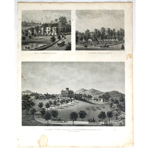
Property of F.A.Halstead Bedford Station, The Halstead Homestead at Bedford and Inland Vale residence of J.S.Libby, Westchester Co. NY North Salem.
Three heliographic prints on one sheet : "Property of F.A.Halstead Bedford Station", "The Halstead Homestead at Bedford" and "Inland Vale residence of J.S.Libby, Westchester Co. NY North Salem" after design by R.K.Sneden.From Beer's famous county atlas "Atlas of New York and vicinity, a documentary record of nineteenth century life and delightful specimens of American folk art". F. W. Beers, along with other members of his family, were among the leading county atlas publishers in period immediat...
$90
Maker : DE BEERS, F.W.
Place : New York
Date : 1867
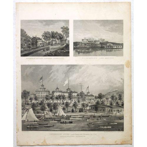
Residence of A.S. Doane Doanesburg Putnam Co. N.Y. - N. L. Thompsons's lake Mahopac - The Gregory House lake Mahopac Putnam Co N. Y. Lewis H. Gregory Proprietor.
Three heliographic prints on one sheet : "Residence of A.S. Doane Doanesburg Putnam Co. N.Y. (120x150mm.) / N. L. Thompsons's lake Mahopac (120 x 160mm.) / The Gregory House lake Mahopac Putnam Co N. Y. Lewis H. Gregory Proprietor. (210 x 320mm.)." After design by R.K.Sneden (120 x 160mm.).From Beer's famous county atlas "Atlas of New York and vicinity", "a documentary record of nineteenth century life and delightful specimens of American folk art. F. W. Beers, along with other members of his fa...
$90
Maker : DE BEERS, F.W.
Place : New York,1867
Date : 1867
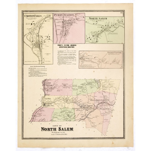
Town of North Salem.
Fine lithographed map of the town of North Salem. The map provides the names of specific homeowners, as well as information about the occupations and physical locations of the various tradesmen in each village from Beer's famous county atlas "Atlas of New York and vicinity," "a documentary record of nineteenth-century life and delightful specimens of American folk art." F. W. Beers, along with other members of his family, were among the leading county atlas publishers in the period immediately ...
$90
Maker : DE BEERS, F.W.
Place : New York
Date : 1867