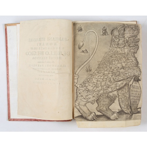
De Bello Belgico, Decas Prima / Decas Secunda.
With 2 engraved titles of the 'Leo Belgicus', with one paw resting on a shield bearing the title, large woodcut printer's device on the colophons, and 30 richly engraved views and plans of battles and sieges, 28 double-page and 2 full-page, by Johanness W.Bauer, J.Miele, Jacomo Cortese, a.o. Two examples of the famous Leo Belgicus map are included. Among the greatest decorative works of early cartography is a series of arresting maps showing The Netherlands and Belgium in the shape of a lion.Thi...
€6.900
Maker : STRADA, Famiano.
Place : Rome, Franciscus Corbelletus
Date : 1632-1647
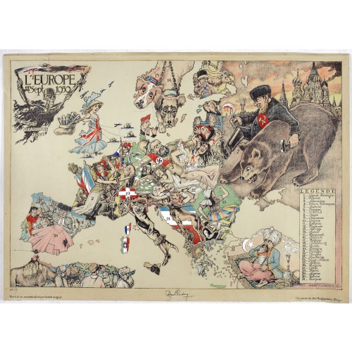
L'Europe en Sept 1939. Ille terrarum mihi angulus ridet.
A rare oversized serio-comic map of Europe at the start of the Second World War depicting stereotypes of 31 countries, as listed in the key lower right, including Britain as a woman with battleships on leads; France as Marianne, leading her troops into battle; Germany, with a swastika sash, stabbing a female Poland; and Russia as a Cossack holding a hammer and sickle, his arm around a large brown bear. Very scarce, although as mentioned on the map 150 were printed, only three, nos. 8, 9, 10, 13...
€9.000
Maker : VLAANDEREN, Cornelis André
Place : Bruges, Leon Burghgraeve
Date : 1939
Ware affbeeldinge wegens het casteel ende stadt Batavia. . .
A reduced version of Clement de Jonghe (1650) plan of Jakarta from 1650. The town plan has a vignette at the bottom showing Jakarta from the sea with the volcanoes Mount Gede, Mount Pangrnago and Mount Salak in the background. Engraved for Arnoldus Montanus "Gedenkwaerdige gesantschappen der Oost-Indische maatschappy in ’t Vereenigde Nederland. . ." (1669) but reissued by Pieter van der AA.Batavia, present-day Jakarta, the Dutch center of trading activities in the East Indies. European and nat...
$800
Maker : VANDER AA, P.
Place : Leiden
Date : 1719
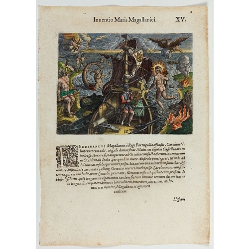
Inventio Maris Magallanici.
Allegorical scene allegorical image celebrating the circumnavigation of the earth by Ferdinand Magellan. The image shows Magellan on board of his ship, surrounded by mythological figures including Apollo with sun and lyre, Zeus on his throne of clouds, Adam and Eve. A bird carrying an elephant and a depiction of the Tierra del Fuego.The image also includes cannon, banner with the double-headed Hapsburg eagle, anchor, broken mast, navigational instruments such as armillary sphere and dividers, se...
$400
Maker : DE BRY, Th.
Place : Frankfurt
Date : 1594
[Lot of 2 maps] Important plan of Port Bucarelli 1384 / Chart of the entrance of "Bassin de L'Quest", La Perouse. 1709
Chart of the entrance of "Bassin de L'Quest", La Perouse. 1709 / With antique print of Alaska] Pirogue du port des Francais. / Pirogue, trouvee au port des Francais. 5958 / [Antique map of Alaska] Plan der Haven van Namganoodha in het eiland van Oonolaska. 2665 / Antique detail chart of the Nootka Channel] Schets van het Kanaal van Nootka. 3860. Plus 6 prints of natives of Alaska and their utensils. A plan of Port Bucarelli, Jean François Galoup, Comte de la Pérouse (1741-88), outstanding Fren...
€350
Maker : La Pérouse, J.B.G. Comte de.
Place : Paris
Date : 1797
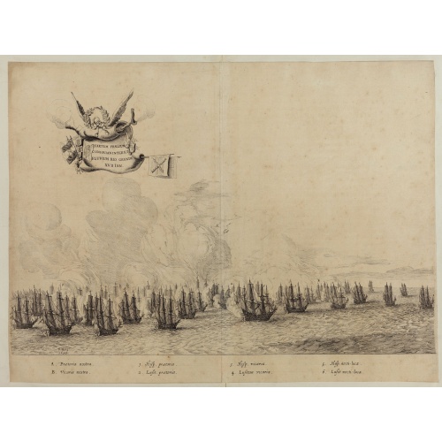
Quartum Praelium Coniovian inter et Fluvium Rio Grande XVII Ian
Decorative engraving of the fourth sea battle with the Portuguese fleet offshore at the Rio Grande, in 1640. Engraved by J. van Brosterhuyzen after a design by Frans J. Post (1612-1680). Below the engraving a numbered key (1-6). Signed in the plate "F. Post 1645" and decorative title cartouche, with "[Quartum praelium coniovian inter et fluvium Rio Grande XVII Jan" in the upper left corner.Taken from C. BARLAEUS, Rerum per octennium in Brasilia (...).
$450
Maker : POST, F. J.
Place : Joannes Blaeu, Amsterdam 1647
Date : 1647
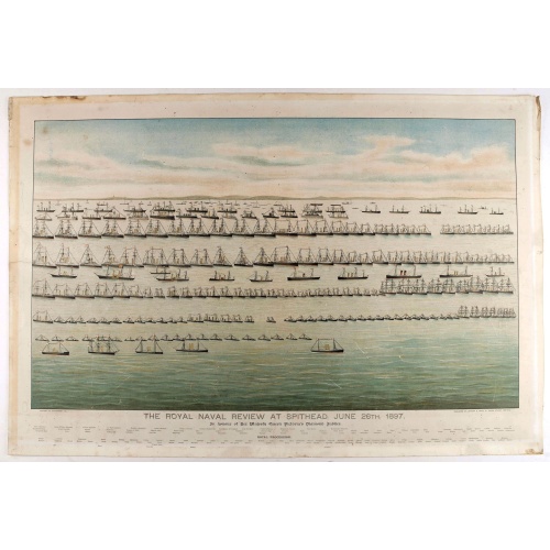
The Royal Naval review at Spithead, June 26th, 1897. In Honour of Her Majesty Queen Victoria's Diamond Jubilee.
A very decorative and large chromolithographed plate showing a line up of international vessels at Spithead, June 26th, 1897 In Honour of her Majesty Queen Victoria'a Diamond Jubilee. Below names of all International and British vessels giving presence on that day.
$750
Maker : JOGHNSON & LOGAN
Place : Portsea
Date : ca. 1897
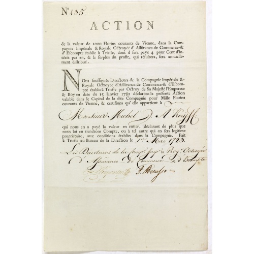
Share of 1000 Florins to Michel de Knyff. N° 135.
Share of 1000 Florins, paid in four tranches at 250 Florins of Vienna, from "Compagnie Imperiale & Royale Octroyee d'Assurance de Commerce & d'escompte." dated in manuscript, Trieste, May 1, 1783. Share made out to Michel de Knyff of Antwerp.In their high-flying plans, the proud Habsburg monarchy very often relied on the money of the wealthy Antwerp bankers and wholesalers, who at that time belonged to the Austrian Netherlands. Among the financiers was the famous bank of Ertborn & Fils among man...
$1.500
Maker : COMPAGNIE IMPERIALE & ROYALE
Place : Trieste
Date : 1782 - 1783
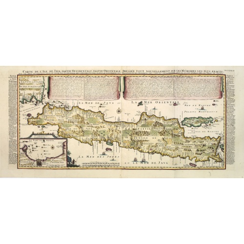
Carte de l'Ile de Java. . .
An inset plan of Batavia and clearly indicated rice fields, mountains, forests, towns in profile, and even elephants, suggesting the wealth of detail found on this map. Modeled on Hadrien Reland's important Dutch map of a few years earlier, the superb topographical detail is complemented by drapery style cartouche and side panels which provide a full French text description of the island, its topography, history, flora, fauna and inhabitants. Above the map are two drapery style title banners wri...
$1.750
Maker : CHATELAIN, H.
Place : Amsterdam
Date : 1720
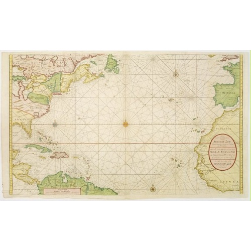
Nieuwe Wassende Graade Zee Kaart over de Spaanse Zee Vant Kanaal tot 't Eyland Cuba in Westindia. . .
¤ Engraved by I.van Anse. A very representative example of a Dutch chart of the Atlantic, showing the north-east coast of America, the coasts of Africa and Europe and South America, including Florida and the West Indies. Gerard issued ca. 40 charts of this exceptionally large format. Collections of these large-size charts were issued in the shining sea-torch and as separate atlases.Title in Dutch, French and English. North America from Labrador to West Florida, including New Foundland, the Gulf...
$3.000
Maker : VAN KEULEN, G.
Place : Amsterdam
Date : 1728
Calendrier de la cour, tiré des éphémérides, pour l'Année bissextile.. / Notebook bearing silver plates with the VOC monogram.
A personal gift, only made for the trustees of the V.O.C. The silver plate was probably made by Drick van Hengel and Company because an entry in the diary of mintmaster Johann Georg Holtzhey for the years 1777-1784 reveals that silver work for book clasps for the Delft and Rotterdam chambers was to be supplied by Dirck van Hengel and Company on a yearly basis.The almanac contains a list of the daily sun rise and sun set, the phases of the moon, etc. Jacques Collombat (Grenoble, circa 1668 - idem...
$4.500
Maker : HÉRISSANT, Ve.
Place : Paris/Amsterdam
Date : 1787
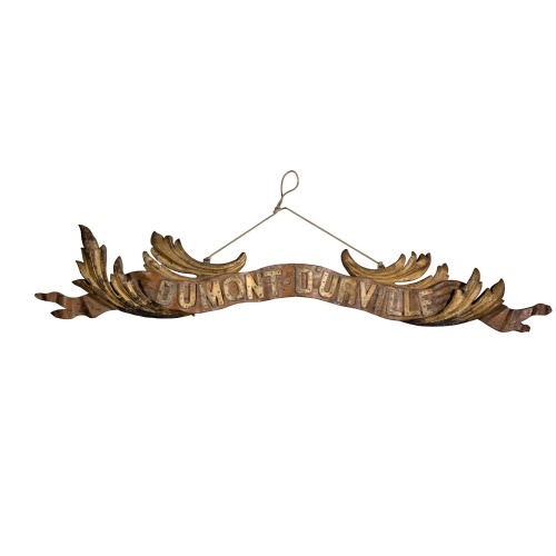
Transom of a ship in gilded carved wood bearing the inscription "DUMONT- DURVILLE"
Decorative transom sign in gilded carved wood bearing the inscription "DUMONT- DURVILLE" in a foliage environment. The transom usually kept the name of the ship and was often well-decorated.A transom is the flat, vertical surface at the back of a ship that connects the two sides of the hull. The sign holds the name of the great French explorer Jules Dumont d'Urville D’Urville who first visited New Zealand in 1824 as second-in-command to Louis Duperrey. On his second voyage of exploration and...
$7.500
Maker : ANONYMOUS
Place : France
Date : 1880
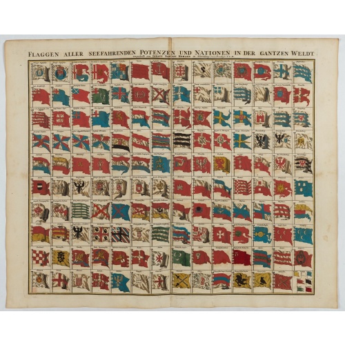
Flaggen aller seefahrenden potenzen und nationen…
A highly decorative and beautiful print with 139 flags of the sea-faring nations, factions, and trading companies. Among the more interesting flags are those of the Dutch West India Company (G.WC. /Geoctroyeerde Westindische Compagnie) and the Dutch East India Company (V.O.C. / Vereenigde Oostindische Compagnie). This plate is probably derived from a Dutch flag print issued by Cornelis Danckerts c. 1700.
$1.000
Maker : HOMANN, J.B.
Place : Nuremberg
Date : 1750
[Lot of 15 maps/plans of northern France] Gouvernement d' Orleans et la Generalite divisee en ses Elections.
Alexis-Hubert Jaillot (1632-1712), French cartographer. He joined the Sanson heirs and redrew Nicolas Sanson's maps on a larger scale. 'Atlas Nouveau' (1674), sea-atlas ' Le Neptune François' (1693).An attractive large-format map depicting Orleans and vincinity. Embellished with a large title-cartouche and a cartouche with scales.Newly engraved for the counterfeited edition of the ' Atlas Nouveau', published by Pieter Mortier in Amsterdam. Ref.: Pastoureau, Les Atlas Français XVIe-XVIIe Siècl...
€500
Maker : Jaillot, A.-H. / P. Mortier.
Place : Amsterdam
Date : 1693
[Lot of 6] Carte de la Baye d'Hocsieu. Fukin. (3 Maps + 3 Gravure of China)
[Lot of 6 items]. (3 Maps +3 gravure )- Carte de la Baye d'Hocsieu et des Entrees de la Riviere de Chang Situees dans la Province de Fokyen. J.N.Berlin 1748- Carte de l’Isle de Cheu Chan ou Isle de Chusan de la Province de Che-Kiang Avec les Costes et Isles voisines- Carte de la Baye d'Hocsieu et des Entrées de la Riviere de Chang. Situées, Dans la Province de Fokyen- Tempel van Quang-Que-Myau- Temple Chinois- De Seije-Reedery, uit de HaldeA detailed small chart of the estuary of the Chiang...
€280
Maker : BELLIN, J. N.
Place : Amsterdam
Date : 1759
[Lot of 5 maps] Kaart van de noord-west kust van Amerika en de noord-oost kust van Asia.
- Kaart van de noord-west kust van Amerika en de noord-oost kust van Asia. Opgenoomen in de Jaaren 1778 en 1779.Captain James Cook (1728-79), explorer, circumnavigator and hydrographer. Three voyages, 1768-71, 1772-75 and 1776-79. From 1778 on printed editions of ' Captain Cook's Travels' appeared in English, Italian, French and Dutch east coast. From a Dutch edition of Cook's voyages'.- Carte d'une Partie DE L'AMERIQUE SEPTRIONALE qui comprendles POSSESSIONA ANGLAISES. This map depicts colonia...
€300
Maker : COOK, J.
Place : Leiden
Date : 1795-1803
[Lot of 8 maps of European Russia] Partie Septentrionale de la Russie Europeenne ou sont distinguees exactement toutes les Provinces
[Lot of 8 maps of European Russia]- Partie Septentrionale de la Russie Européenne òu sont distinguées exactement toutes les Provinces (1753)- Carte des Pais Habites par les Samojedes et Ostiacs (1757)- 2x Carte de la Partie Septentrionale de la Russie Européenne- Partie Septentrionale de la Russie Europeenne ou sont distinguees exactement toutes les Provinces (1753)- Nouvelle Carte des Etats du Grand duc de Moscovite en Europe (1714)- Partie Meridionale de Moscovie Dressee Par G. de L’...
€600
Maker : BELLIN, Jacques Nicolas
Place : Paris
Date : 1757
[Lot of 10 maps] Carte Nouvelle de la Grande Tartary.
Antique map of Asian Russia] Carte Nouvelle de la Grande Tartarie ou de l'Empire du Grand Cham. With 10 maps / views of Asian Russia- Carte Nouvelle de la Grande Tartarie ou de L’empire du Grand Cham (1719)- Baie de castries settee sur la cote orientale de tartarie (1797)- Carte du Kamtchatka Dressee et Gravée par Laurent (1757)- 2x Gezichten der kust van Asiën.- Gezichten der kust van Kamtchatka.- Carte de la Tartarie Occidentale, Pour servir à l'Histoire Générale (1749)- IImperium Rus...
€700
Maker : CHATELAIN, H.
Place : Amsterdam
Date : 1720 - 1730
[Dutch provo Propaganda Poster] De Vrije Maagd Radio
Published in 1969, the year of the student unrest in Europe.Het jaar van de studenten opstanden in Europese landen! DUTCH PROVO POSTERAmsterdammers, luister niet naar de met het kapitaal Kollaborerende Hilversumse radio, maar naar de vrije maagd: 225 mtr middengolfkom naar het Spui beleger de belegeraars !
€200
Maker : Rob Stolk en H. Langhout
Place : Amsterdam
Date : 1969
[Original drawing: Fisher's ships on the beach of Scheveningen.]
Unique pencil drawing: Typical Dutch beach life with flat-bottomed ships on the beach of Scheveningen. Signed in the lower right corner and on the back site with P.A. Beretta (Petrus Augustus Beretta)
€450
Maker : BERETTA, Petrus Augustus Artist
Place : The Netherlands
Date : c. 1850


![[Lot of 2 maps] Important plan of Port Bucarelli 1384 / Chart of the entrance of "Bassin de L'Quest", La Perouse. 1709](/uploads/cache/20473-500x500.jpg)
![[Lot of 15 maps/plans of northern France] Gouvernement d' Orleans et la Generalite divisee en ses Elections.](/uploads/cache/16682-500x500.jpg)
![[Lot of 6] Carte de la Baye d'Hocsieu. Fukin. (3 Maps + 3 Gravure of China)](/uploads/cache/20019-500x500.jpg)
![[Lot of 8 maps of European Russia] Partie Septentrionale de la Russie Europeenne ou sont distinguees exactement toutes les Provinces](/uploads/cache/86005-500x500.jpg)
![[Lot of 10 maps] Carte Nouvelle de la Grande Tartary.](/uploads/cache/85969-500x500.jpg)
![[Dutch provo Propaganda Poster] De Vrije Maagd Radio](/uploads/cache/86256-500x500.jpg)