

La Piovra Russa. Carta Serio-Comica Pel 1878.
Very rare political caricature map by Grossi of the nations of Europe, published in Bologna in the supplement of the newspaper "Le Perroquet / Al papagallo, N° 15, Anno VI.Known as the Octopus Map ; the brooding presence of the Russian Empire depicted as a massive octopus, whose tentacles stretch out towards Europe. In this map, the Octopus has Turkey, Persia and Poland but has been wounded by Crimea and is being fought off by Germany.This map, by Grossi, followed the style created by Frederick...
€1.850
Maker : GROSSI, A.
Place : Bologne
Date : 14 avril 1878
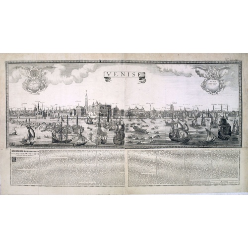
Venise. 1700
Extremely rare panoramic broad sheet panoramic town-view of Venice with underneath in letter press a description of the town's history.The view measures more than 1 meter. The foreground is animated with a great variety of sailing vessels.The printer's address is dated 1699, but the tile has the date 1700. Most likely, Jaillot published the view to celebrate the turn of the century!
€20.000
Maker : JAILLOT, H.
Place : Paris
Date : 1699
A new mape of Ye XVII Provinces of Low Germanie.
Showing all 17 Provinces of the Netherlands before the split between Spain and the Protestant Provinces under the House of Orange.The map was first published. At the same time, the war of independence was still being fought against Philip II. With columns of figures on either side and surmounted by eight city prospects. A famous and most decorative item.A fourth state published by Thomas Basset and Richard Chiswell. The date has been removed and Speed's name has been added to the title cartouche...
$2.300
Maker : SPEED, J.
Place : London, 1676
Date : 1626
L'Amérique divisée en ses principaux Etats Dressée d'après les Cartes de Mr. Bonne
Rare, wall map of America in 2 sheets, after R. Bonne. With 3 inset maps of Hispaniola, Martinique and Hudson Bay. Beautiful title cartouche depicting a Native American leaning on a shell, under a palm tree, the figure is surrounded by typical elements of the flora and fauna of the continent as a beaver and 2 pelicans.
€5.500
Maker : BONNE, R. / LATTRÉ, J.
Place : Paris
Date : 1788
![[Map of the Monterey Peninsula.]](/uploads/cache/48349-500x500.jpg)
[Map of the Monterey Peninsula.]
A lovely example of Jo Mora's Del Monte Properties Company' California's Fun' playground tourist map of the Monterey Peninsular, published in San Francisco in 1927. The rare first state and among the rarest maps by Jo Mora.A lively map full of interesting, fun illustrations of the region. The map borders are surrounded by many small illustrations of modern and historical Monterey. These include animals, historical figures, native Indians, missionaries, cowboys, singing & dancing, the 'gold rush'...
€900
Maker : ROBERTSON, A.M.
Place : San Francisco
Date : 1927
The Sea Coast of France from Ushent to Olone.
Chart showing the Brittany coast from Ushent to Ollone, with Belle-Ile. In insets : Rade de Brest and Mouth of the Loire between St. Nazaire and Nantes.Originally engraved by John Seller, here with the address "Sold by Ri. Mount at the Postern on Great Tower Hill LONDON". Mount and Page was a firm of religious and maritime publishers that flourished in the 18th century. The name became well-known worldwide as an imprint of nautical charts.The firm was founded in 1701 by Richard Mount (1654–172...
€550
Maker : MOUNT, R.. / PAGE, T.
Place : London, ca. 1680
Date : 1680
The Sea Coasts of France from Olone to Cape Machicaca in Biscay . . .
Detailed chart of Biscay Bay, showing the Coast of Brittany. The chart is oriented with north-east at the top and includes two large insets of the Loire River with Nantes and the complete coast of Brittany.Originally engraved by John Seller, here with the address "Sold by Ri. Mount at the Postern on Great Tower Hill LONDON". Mount and Page was a firm of religious and maritime publishers that flourished in the 18th century. The name became well-known worldwide as an imprint of nautical charts.The...
€550
Maker : MOUNT, R.. / PAGE, T.
Place : London
Date : ca. 1680
New York von der Seeseite aus gesehen.
Very decorate view of New-York. J.Hesse was known as a portrait painter and publisher of lithographs. A long panorama of the shoreline from the sea, with sailing vessels and American steamships in the busy port.
€700
Maker : HESSE, J.
Place : Berlin
Date : c. 1850
Pas kaart Van Rio Oronoque Golfo De Paria met d'Eylanden Trinidad, Tabago, Granada, Granadillos, en Bequia . . .
A highly detailed and rare sea chart of the mouth of the Orinoco River, Trinidad, Tabago, St.Vincent and neighboring islands. Oriented with north to the right by two compass roses.A large inset shows Tobago on a larger scale. Taken from De Nieuwe Groote Lichtende Zee-Fakkel, Part IV.Decorative scale cartouche features Neptune with his entourage and natives with trade goods. The chart is further adorned with a monkey atop the title cartouche and a sailing ship.
$900
Maker : VAN KEULEN, J.
Place : Amsterdam
Date : 1684

A general chart of the South Atlantic Ocean Drawn by J.W.Norie hydrographer. Revised & Corrected 1854.
A 2-sheet chart of the South Atlantic Ocean, showing the coast of South America from the mouth of the Amazon to Quito in Peru. The right hand part showing Africa's coast at Angola. Scale: circa 1:8,000,000. Chart of the South Atlantic, in two sheets. Two insets, Port of Ascension and Anchorage off N.W. side of St. Helena.The chart is published for the first time in 1833, according to a date lower part map. This is A Revised & corrected edition by J.W. Norie in 1854
$600
Maker : NORIE, J.W.
Place : London
Date : 1854
Nieuwe gelyk Graadige Paskaart van de Kust van Guiana in West-Indien.
Detailed chart of Guiana in South America. Two scales are given in both maps: Dutch, French and English nautical miles.The inset chart provide detailed view of the Camopi and Maroni or Marowijne Rivers that forms the border between French Guiana and Suriname. The charts are prepared by Johannes Loots and H.Mooy.
$650
Maker : VAN KEULEN, G.
Place : Amsterdam
Date : 1684 - 1704

Carta esférica del Rio de la Plata : desde su embocadura hasta Buenos Aires.
Large nautical chart illustrating the estuary formed by the combination of the Uruguay River and the Paraná River. It forms part of the border between Argentina and Uruguay, with the major ports and capital cities of Buenos Aires in the southwest and Montevideo in the northeast.
$750
Maker : DIRECTION HIDROGRAFICA
Place : Madrid
Date : 1812-1838
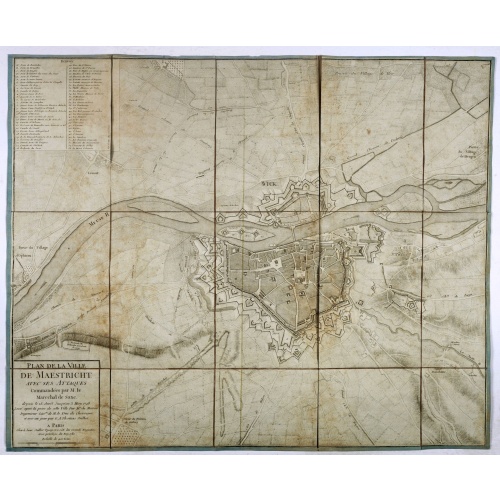
Plan de la ville de Maestricht avec ses attaques commandées par M. le maréchal de Saxe, depuis le 15 avril jusqu'au 3 may 1748 . . .
A plan of Maastricht rising after the capture of the city by the French troops led by the Marshal of Saxony. The city was besieged between 15 April and 3 May 1748, during the War of Succession of Austria.With numbered key (1-53).
$600
Maker : JAILLOT, J.
Place : Paris
Date : 1781

Nieuwe Wassende Graade Zee Kaart over de Spaanse Zee Vant Kanaal tot 't Eyland Cuba in Westindia. . .
¤ Engraved by I.van Anse. A very representative example of a Dutch chart of the Atlantic, showing the north-east coast of America, the coasts of Africa and Europe and South America, including Florida and the West Indies. Gerard issued ca. 40 charts of this exceptionally large format. Collections of these large-size charts were issued in the shining sea-torch and as separate atlases.Title in Dutch, French and English. North America from Labrador to West Florida, including New Foundland, the Gulf...
$3.000
Maker : VAN KEULEN, G.
Place : Amsterdam
Date : 1728
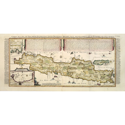
Carte de l'Ile de Java. . .
An inset plan of Batavia and clearly indicated rice fields, mountains, forests, towns in profile, and even elephants, suggesting the wealth of detail found on this map. Modeled on Hadrien Reland's important Dutch map of a few years earlier, the superb topographical detail is complemented by drapery style cartouche and side panels which provide a full French text description of the island, its topography, history, flora, fauna and inhabitants. Above the map are two drapery style title banners wri...
$1.750
Maker : CHATELAIN, H.
Place : Amsterdam
Date : 1720
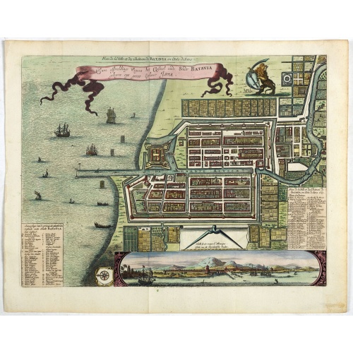
Ware affbeeldinge wegens het casteel ende stadt Batavia. . .
A reduced version of Clement de Jonghe (1650) plan of Jakarta from 1650. The town plan has a vignette at the bottom showing Jakarta from the sea with the volcanoes Mount Gede, Mount Pangrnago and Mount Salak in the background. Engraved for Arnoldus Montanus "Gedenkwaerdige gesantschappen der Oost-Indische maatschappy in ’t Vereenigde Nederland. . ." (1669) but reissued by Pieter van der AA.Batavia, present-day Jakarta, the Dutch center of trading activities in the East Indies. European and nat...
$800
Maker : VANDER AA, P.
Place : Leiden
Date : 1719
L'Europe en Sept 1939. Ille terrarum mihi angulus ridet.
A rare oversized serio-comic map of Europe at the start of the Second World War depicting stereotypes of 31 countries, as listed in the key lower right, including Britain as a woman with battleships on leads; France as Marianne, leading her troops into battle; Germany, with a swastika sash, stabbing a female Poland; and Russia as a Cossack holding a hammer and sickle, his arm around a large brown bear. Very scarce, although as mentioned on the map 150 were printed, only three, nos. 8, 9, 10, 13...
€9.000
Maker : VLAANDEREN, Cornelis André
Place : Bruges, Leon Burghgraeve
Date : 1939

Kaerte en Afbeeldinge vande Geheele Jurisdictie van Stantdarbuyten Gelegen in de Generaliteit onder Marquisaet van Bergen op den Zoom
With a large title cartouche with signature of the maker Adriaan van der Ende, : Kaerte en Afbeeldinge vande Geheele Jurisdictie van Stantdarbuyten Gelegen in de Generaliteit onder Marquisaet van Bergen op den Zoom, gemaekt, en in den Jare van 1733, 1734, 1735 gemeten by my ondergetz… Willemstadt den 8 Julij 1737 Adr: van Enden.Adriaan van de Ende was a surveyor, appointed by the Council of Brabant in 1720, then living in Heyningen. Was later living and active in Willemstad.Other manuscript m...
$2.500
Maker : VAN DE ENDEN, A.
Place : Willemstadt
Date : 1737

A Map of the most Inhabited part of New England containing the Provinces of Massachusetts Bay and New Hampshire, with the Colonies of Connecticut and Rhode Island.
A copper engraving in four sheets, published in Georges Louis Le Rouge, in his "Atlas Ameriqua in Septentrional Contenant les details des differentes provinces, de ce vaste continent, traduit des cartes levées par ordre du Gouvernement Britannique". This is a very close copy of the second edition, the second issue of the Jefferys-Green map, even down to the spelling, in the statement of sources, of Connecticut with 'k's (but translated into French). The title cartouche is also a straight copy, ...
€4.000
Maker : LE ROUGE, G. L.
Place : Paris, 1777
Date : Paris, 1777
Zee caerte vande Sondt tvermaerste van Danemarcke . . .
A detailed chart of the coast of Denmark and its islands, Copenhagen in the center of the chart. West to the top. It is decorated by a title, scale and descriptive cartouche, a compass rose, several vessels and sea monsters, and depictions of mountains, fields, trees, small villages and animals.The chart shows soundings, sandbanks, landmarks and coastal profiles.Chart from an early Dutch text edition of this landmark contribution to the science of navigation. Waghenaer's own experiences as a pil...
$3.000
Maker : WAGHENAER, L. J.
Place : Leiden, Plantijn
Date : 1585