
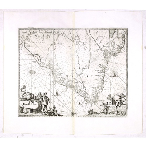
Brasilia.
Very fine decorative map od Brazil with west to the top. From the book "A Collection of Voyages and Travels" by Churchill and the map came from the part containing a description Nieuhoff's travels in Brazil.
$550
Maker : CHURCHIL, J.
Place : London, Printed for A. and J. Churchill
Date : 1703
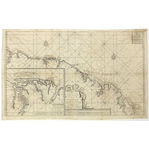
Nieuwe gelyk Graadige Paskaart van de Kust van Guiana in West-Indien.
Detailed chart of Guiana in South America. Two scales are given in both maps: Dutch, French and English nautical miles.The inset chart provide detailed view of the Camopi and Maroni or Marowijne Rivers that forms the border between French Guiana and Suriname. The charts are prepared by Johannes Loots and H.Mooy.
$650
Maker : VAN KEULEN, G.
Place : Amsterdam
Date : 1684 - 1704

Nieuwe Wassende Graade Zee Kaart over de Spaanse Zee Vant Kanaal tot 't Eyland Cuba in Westindia. . .
¤ Engraved by I.van Anse. A very representative example of a Dutch chart of the Atlantic, showing the north-east coast of America, the coasts of Africa and Europe and South America, including Florida and the West Indies. Gerard issued ca. 40 charts of this exceptionally large format. Collections of these large-size charts were issued in the shining sea-torch and as separate atlases.Title in Dutch, French and English. North America from Labrador to West Florida, including New Foundland, the Gulf...
$3.000
Maker : VAN KEULEN, G.
Place : Amsterdam
Date : 1728
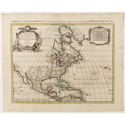
L'Amerique septentrionale, Dressée sur les memoires les plus recens. . .
A very detailed map extending from Hudsons Bay to Panama, and including the West Indies. The map is a later copy of Guillaume de L'Isle's foundation map of North America, originally prepared in 1700.The de L'Isle was one of the earliest maps to restore the peninsula form for California, and has a much improved outline for the Great Lakes and Mississippi valley.The map shows select towns and cities, forts, Indian villages and tribal territory and relief.
$900
Maker : COVENS, J. / MORTIER, C.
Place : Amsterdam
Date : 1739
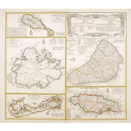
Dominia Anglorum in praecipuis Insulis Americae ut sunt Insula S. Christopheri, Antegoa, Iamaica, Barbados nec non Insula Bermudes vel Sommers . . .
Four maps of the islands of West Indies (St. Christoph "Delineatio Insulae St, Christophori alias I. Kitts", Antigua "Insula Antegoa", Barbados "Insula Barbadoes" and Iamaica "Insula Iamaica") and a map of Bermudas ("Insulae Bermudes") showing British possessions in the Caribbean. At the upper right of the sheet text in German relating to the areas depicted.A second edition with Bermudes. The first edition uses the name Bermudos.
$500
Maker : HOMANN HEIRS.
Place : Nuremberg
Date : 1740
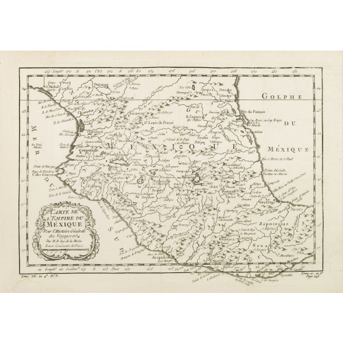
Carte de L'Empire du Mexico.
A good engraved map of Mexico, with rococo title cartouche lower left. From l'Histoire générale des voyages .
$80
Maker : BELLIN, J.N.
Place : Paris
Date : 1754
L'Amerique divisée en ses principaux Etats..
Uncommon map published by Lattré. This map is most notable for its depiction of "Mer de L'Ouest" or "Sea of the West". A great sea, easily the size of the Mediterranean, to flow from the then-known Strait of Juan de Fuca. Showing an opening to the ocean from this great sea at roughly in North California or Oregon and Quivira somewhere in Idaho. Fattening Alaska and appropriately leaving blank the unknown parts of Northern America. Listing Indian nations, towns such as Santa Fe.
$900
Maker : JANVIER,Sr.
Place : Paris
Date : 1760
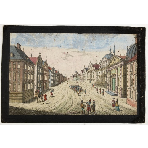
Prospect des Haupt Plazes der Untern Stadt zu Quebec.
A so-called optical print showing a decorative imaginary town view of Québec, with a street view with soldiers marching and pedestrians, an idealized view depicting Québec as a typical European city.By Franz Xavier Habermann (1721-1796).This print is a fine example of this illusionary printmaking, but also as a testament to the strong interest by Europeans in America at the time and also as a fine example of the perspective view.In the eighteenth and nineteenth centuries, there were many popul...
$500
Maker : ACADEMIE
Place : Augsburg, ca.1780
Date : 1780
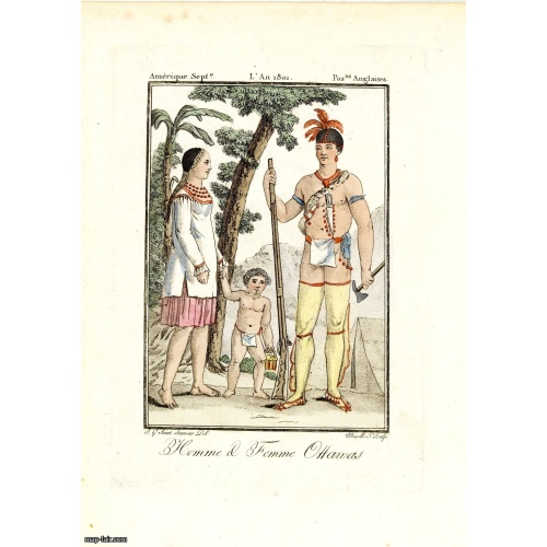
Homme & Femme Ottawas.
Hand-colored mezzotint of Native Americans engraved by Félix Mixelle and Lachaussée Jeune after Jacques Grasset de Saint-Sauveur.As an etcher, drawer and writer, Grasset de Saint-Sauveur was a prolific polygraph in keeping with the encyclopedic spirit of the eighteenth century: he wrote exotic novels as well as documentary works on various subjects. Called by one of his biographers a drawer without genius but a good example of the taste of his time, Grasset de Saint-Sauveur was literally bewit...
$75
Maker : GRASSET DE SAINT SAUVEUR,J.
Place : Paris,
Date : 1806
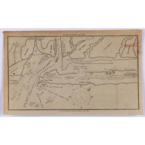
Little Egg Harbour.
A small sea chart showing Little Egg Harbour east of Tucker's Island. This map was published in the “American Coast Pilot”, a detailed guide to harbors, capes and headlands on the east coasts of North and South America. It includes information on winds, currents, tides as well as latitudes and longitudes. The American Coast Pilot was published between 1796 and 1861, until it was replaced by the US Coast Survey.Edmund March Blunt (1770–1862) was an American navigator, author, and publisher ...
$50
Maker : BLUNT, E.
Place : New York, 1817
Date : 1817
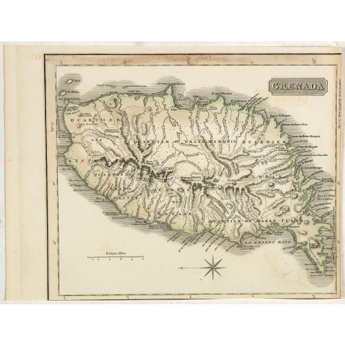
Grenada.
A delightfully detailed map the West Indian island Grenada by John Thomson. The map displays excellent detail concerning roads, rivers, towns, bays, harbours and other interesting topographical details.Thomson (1777-c1840) was a Scottish cartographer from Edinburgh, celebrated for his 1817 New General Atlas, published by himself in Edinburgh, John Cumming in Dublin, and Baldwin, Cradock, and Joy in London.
$50
Maker : THOMSON, J.
Place : Edenburgh
Date : 1821
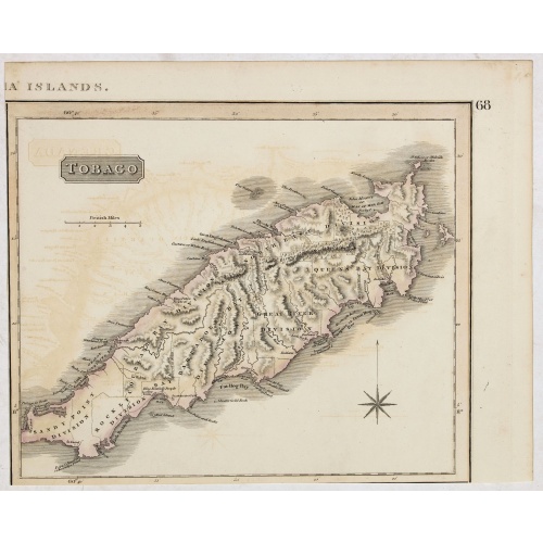
Tobago.
A delightfully detailed map of the West Indian island Tobago by John Thomson. The map displays excellent detail concerning roads, rivers, towns, bays, harbors, and other interesting topographical details.Thomson (1777-c1840) was a Scottish cartographer from Edinburgh, celebrated for his 1817 New General Atlas, published by himself in Edinburgh, John Cumming in Dublin, and Baldwin, Cradock, and Joy in London.
$50
Maker : THOMSON, J.
Place : Edenburgh
Date : 1821
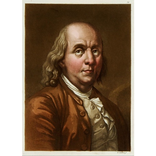
Portrait de Benjamin Franklin.
Portrait de Benjamin Franklin. From Giulio Ferrario's work Le Costume ancien et moderne ou histoire du gouvernement, de la milice, de la religion, des arts, etc. published in Milan by the author between 1816 and 1827.This aquatint engraved plate was color printed on fine wove paper of a soft aged white color, bearing the embossed seal of authenticity impressed at the time of publication with the legend “Il Costume Antico E Moderno” surrounding the initials GF. A beautifully hand colored aq...
$75
Maker : FERRARIO, G.
Place : Milan, 1827
Date : 1827

Carta esférica del Rio de la Plata : desde su embocadura hasta Buenos Aires.
Large nautical chart illustrating the estuary formed by the combination of the Uruguay River and the Paraná River. It forms part of the border between Argentina and Uruguay, with the major ports and capital cities of Buenos Aires in the southwest and Montevideo in the northeast.
$750
Maker : DIRECTION HIDROGRAFICA
Place : Madrid
Date : 1812-1838
-500x500.jpg)
Etats-Unis de l'Amérique du nord.
Detailed map of North America, prepared by Charles V. Monin (fl.1830-1880) a French cartographer of Caen and Paris. Published in Atlas Universel de Géographie Ancienne &c Moderne en 42 Cartes dressé par C.V. Monin. Engraved by Laguillermie.
$75
Maker : MONIN, C.V.
Place : Paris
Date : 1845
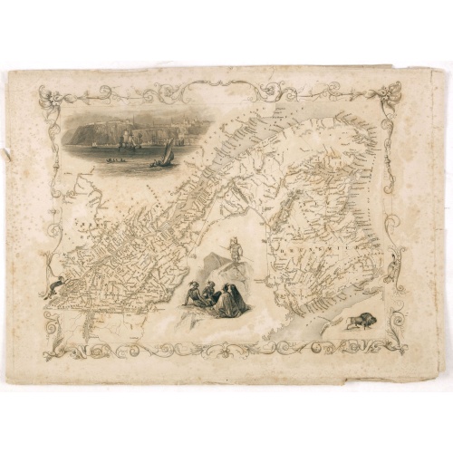
East Canada and New Brunswick.
This is John Tallis’ map of East Canada or what is now Quebec and New Brunswick. Includes Montreal, Quebec City, and the St. Lawrence River valley. Features five vignettes which include American Indian warriors and a spectacular view of Quebec City. The whole is surrounded by a decorative vine motif border. The vignettes for this map were drawn by H. Warren and engraved by J. B. Allen. The map itself is the work of John Rapkin. The Illustrations after a design by H. Warren and engraved by J Ra...
$75
Maker : TALLIS, J.
Place : London
Date : 1851

Amérique Méridionale.
Map of South America.Lovely map from one of the last decorative atlases of the nineteenth century.The rather simple map is framed by horses, Indians, jaguars, tapirs, and mining, as well as personifications of the rivers Amazon and La Plata at the top of the map. Victor Levasseur's "Atlas National Illustré" and "Atlas Universel Illustré" are among the last great decorative atlases published. This map comes from the Atlas National Illustré.
$90
Maker : LEVASSEUR, V.
Place : Paris, A. Combette
Date : 1852

A general chart of the South Atlantic Ocean Drawn by J.W.Norie hydrographer. Revised & Corrected 1854.
A 2-sheet chart of the South Atlantic Ocean, showing the coast of South America from the mouth of the Amazon to Quito in Peru. The right hand part showing Africa's coast at Angola. Scale: circa 1:8,000,000. Chart of the South Atlantic, in two sheets. Two insets, Port of Ascension and Anchorage off N.W. side of St. Helena.The chart is published for the first time in 1833, according to a date lower part map. This is A Revised & corrected edition by J.W. Norie in 1854
$600
Maker : NORIE, J.W.
Place : London
Date : 1854
![Westelijk Halfrond. [Western hemisphere]](/uploads/cache/25524-500x500.jpg)
Westelijk Halfrond. [Western hemisphere]
Uncommon world map view of the western and eastern hemispheres of North and South America, Asia. Lithography by J.H. van Weijer, published in Atlas der geheele Aarde in 24 kaarten.
$50
Maker : SCHOLTENS, A.L.
Place : Groningen
Date : ca. 1860
-500x500.jpg)
Town of Verplanck / Crugers / Croton Landing.
Fine lithographed map of the town of Verplanck / Crugers / Croton Landing. The map provides the names of specific homeowners, as well as information about the occupations and physical locations of the various tradesmen in each village from Beer's famous county atlas "Atlas of New York and vicinity," "a documentary record of nineteenth-century life and delightful specimens of American folk art." F. W. Beers, along with other members of his family, were among the leading county atlas publishers in...
$90
Maker : DE BEERS, F.W.
Place : New York
Date : 1867