

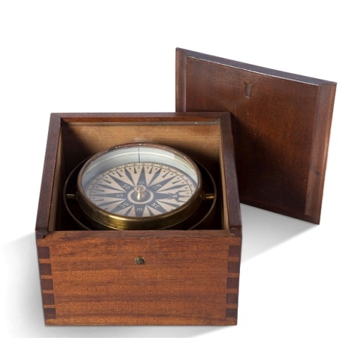
Mariner’s compass
Inverted compass called "snitch" in wood painted in imitation of tortoiseshell and brass, signed "Ing MANN Maker Water Street Liverpool".
$3.000
Maker : MANN
Place : Liverpool
Date : ca. 1785
-500x500.jpg)
Calendrier de la cour, tiré des éphémérides, pour l'Année bissextile.. / Notebook bearing silver plates with the VOC monogram.
A personal gift, only made for the trustees of the V.O.C. The silver plate was probably made by Drick van Hengel and Company because an entry in the diary of mintmaster Johann Georg Holtzhey for the years 1777-1784 reveals that silver work for book clasps for the Delft and Rotterdam chambers was to be supplied by Dirck van Hengel and Company on a yearly basis.The almanac contains a list of the daily sun rise and sun set, the phases of the moon, etc. Jacques Collombat (Grenoble, circa 1668 - idem...
$4.500
Maker : HÉRISSANT, Ve.
Place : Paris/Amsterdam
Date : 1787
Early 19th century magnetic dry card compass with wooden bowl,
Brass dry rose marine compass, in its mahogany case. The mariner's compass, which enabled mariners to know the direction in which they were sailing, has always been one of the most important navigational instruments.This example is mounted in a wooden box to keep it safe.. The compass itself is mounted on brass gimbals to keep it steady on a moving ship. It has a single iron needle with a brass cap that rests on a spike projecting from the bottom of the bowl, which also contains some lead to wei...
$1.750
Maker : ANONYMOUS
Place : Unknown
Date : ca. 1800
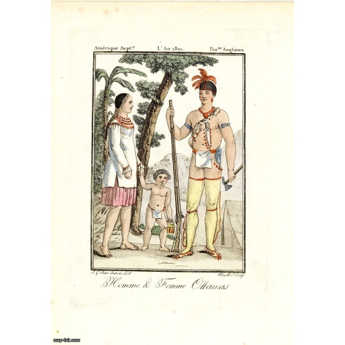
Homme & Femme Ottawas.
Hand-colored mezzotint of Native Americans engraved by Félix Mixelle and Lachaussée Jeune after Jacques Grasset de Saint-Sauveur.As an etcher, drawer and writer, Grasset de Saint-Sauveur was a prolific polygraph in keeping with the encyclopedic spirit of the eighteenth century: he wrote exotic novels as well as documentary works on various subjects. Called by one of his biographers a drawer without genius but a good example of the taste of his time, Grasset de Saint-Sauveur was literally bewit...
$75
Maker : GRASSET DE SAINT SAUVEUR,J.
Place : Paris,
Date : 1806
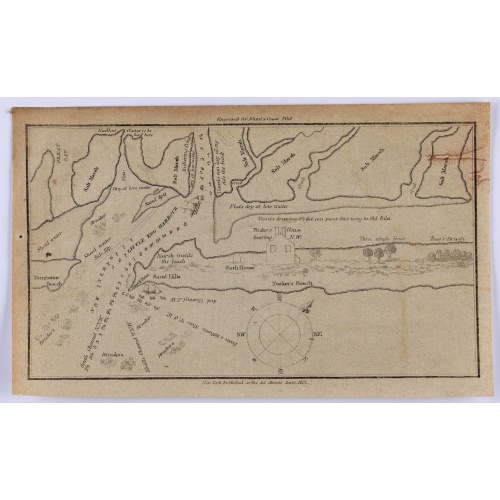
Little Egg Harbour.
A small sea chart showing Little Egg Harbour east of Tucker's Island. This map was published in the “American Coast Pilot”, a detailed guide to harbors, capes and headlands on the east coasts of North and South America. It includes information on winds, currents, tides as well as latitudes and longitudes. The American Coast Pilot was published between 1796 and 1861, until it was replaced by the US Coast Survey.Edmund March Blunt (1770–1862) was an American navigator, author, and publisher ...
$50
Maker : BLUNT, E.
Place : New York, 1817
Date : 1817
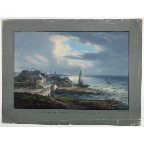
Vue de Gattweick et de l'embouchure du Rhin, dans la Mer du Nord.
Very decorative view of Katwijk. Signed lower right, Louis Bleuler au chateau de Laufen . Original design by Louis Bleuer. This gouache was the model for his aquatint in his famous book 80 Rheingegenden published in 1826.
$1.500
Maker : BLEULER, L.
Place : gERMANY
Date : 1820
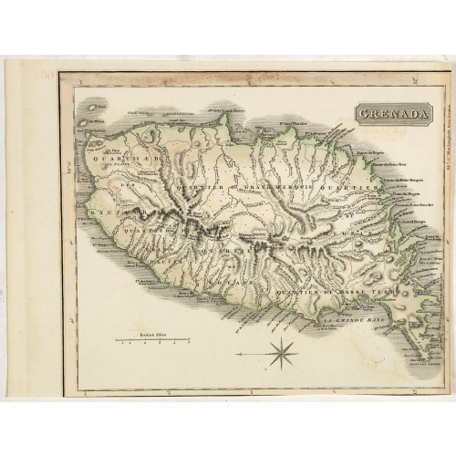
Grenada.
A delightfully detailed map the West Indian island Grenada by John Thomson. The map displays excellent detail concerning roads, rivers, towns, bays, harbours and other interesting topographical details.Thomson (1777-c1840) was a Scottish cartographer from Edinburgh, celebrated for his 1817 New General Atlas, published by himself in Edinburgh, John Cumming in Dublin, and Baldwin, Cradock, and Joy in London.
$50
Maker : THOMSON, J.
Place : Edenburgh
Date : 1821
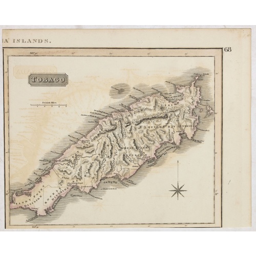
Tobago.
A delightfully detailed map of the West Indian island Tobago by John Thomson. The map displays excellent detail concerning roads, rivers, towns, bays, harbors, and other interesting topographical details.Thomson (1777-c1840) was a Scottish cartographer from Edinburgh, celebrated for his 1817 New General Atlas, published by himself in Edinburgh, John Cumming in Dublin, and Baldwin, Cradock, and Joy in London.
$50
Maker : THOMSON, J.
Place : Edenburgh
Date : 1821

Eastern passage to China. sheet 1.
James Horsburgh early chart of the coasts of Java, Bali, Lombok, with part of Sulawesi, and Borneo. Insets of "Sketch of Bally Strait", Sketch of Lombock Strait", Plan of Allas Strait", "Sketch of Sappy Strait".The chart shows depth soundings & both topographical and hydrographical details and proposed sailing directions in the Sunda Straits. Filled with several coastal profiles, which were of great help for the sailor.In top Horsburgh thanks for the aid he has gotten for preparing this chart : ...
$3.000
Maker : HORSBURGH, JAMES, F.R.S
Place : London
Date : 1824
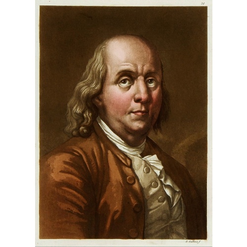
Portrait de Benjamin Franklin.
Portrait de Benjamin Franklin. From Giulio Ferrario's work Le Costume ancien et moderne ou histoire du gouvernement, de la milice, de la religion, des arts, etc. published in Milan by the author between 1816 and 1827.This aquatint engraved plate was color printed on fine wove paper of a soft aged white color, bearing the embossed seal of authenticity impressed at the time of publication with the legend “Il Costume Antico E Moderno” surrounding the initials GF. A beautifully hand colored aq...
$75
Maker : FERRARIO, G.
Place : Milan, 1827
Date : 1827

Carta esférica del Rio de la Plata : desde su embocadura hasta Buenos Aires.
Large nautical chart illustrating the estuary formed by the combination of the Uruguay River and the Paraná River. It forms part of the border between Argentina and Uruguay, with the major ports and capital cities of Buenos Aires in the southwest and Montevideo in the northeast.
$750
Maker : DIRECTION HIDROGRAFICA
Place : Madrid
Date : 1812-1838
-500x500.jpg)
Holland & Belgium.
An attractive steel engraved map of Holland and Belgium. Map flanked by France and Prussia. Duchy of Luxembourg included. Many place names and physical features shown. 4 mileage scales given.The Arrowsmith family members were among the most respected and influential cartographers of the nineteenth century. Taken from 'The London Atlas of Universal Geography…' John Arrowsmith (1790-1873) joined his uncle, Aaron Arrowsmith in mapmaking in London in 1810. Upon the death of his uncle in 1823, the ...
$110
Maker : ARROWSMITH, John
Place : London, 1839
Date : 1839

Regno de' Paesi-Bassi compresa la Olanda . . . / La Svizzera . . .
Two rare and detailed maps of The Netherland (210 x 230mm. ) and Switzerland (140 x 230mm.) According to the title cartouche, prepared by J.A.Buchon and A de La Sage for l'Atlante Storico, Letterario, Biografico, Archeologico. . . with attributions by Giambatista Albrizzi.Lower left a color-key, giving good detail and information. We were not able to find references to the publisher, engraver or author of this map. Uncommon and in very good condition.
$60
Maker : TASSO, G.
Place : Venice, 1840
Date : 1840
-500x500.jpg)
Kaart van de Gaspar Straaten volgens opnemingen van J.Stolze, D.Ross, enz.
Very large and rare chart centered on the strait between Bangka's southeastern seacoast and Belitung's western shores.Short front views of the coastal relief are shown in the lower-left corner of the map.The chart is prepared by H.L.Osthoff in 1840 and published in 1844 by Jacob Swart. When Gerard Hulst van Keulen died in 1801, his widow ran the firm until her death in 1810, at which time Johannes Hulst van Keulen became the last van Keulen to run the firm.In 1823, Jacob Swart entered the servic...
$900
Maker : HULST VAN KEULEN, Wed.G.
Place : Amsterdam
Date : 1843

Straat Riouw onder opzicht van de commissie tot verbetering der Indische Zeekaarten..
Very large and rare so-called Blue Back chart centered on the strait passing between the Riau Islands. It contains an inset map with enlarged details of Riouw Harbor on Bintang Island.Coastal profiles are shown in the lower-left corner of the chart.The chart is prepared by W.H.Dittlof Tjassens, P.A.J.Bloijs van Treslong Prins and J.van Gogh during an expedition in 1840 by the ship Nehalennia under the command of Captain F.G.van der Plaat. The chart is engraved by D.Veelwaard Jr. And published in...
$1.250
Maker : HULST VAN KEULEN, Wed.G.
Place : Amsterdam
Date : 1843
-500x500.jpg)
Etats-Unis de l'Amérique du nord.
Detailed map of North America, prepared by Charles V. Monin (fl.1830-1880) a French cartographer of Caen and Paris. Published in Atlas Universel de Géographie Ancienne &c Moderne en 42 Cartes dressé par C.V. Monin. Engraved by Laguillermie.
$75
Maker : MONIN, C.V.
Place : Paris
Date : 1845

Kaart van de Reede van Batavia met de verschillende vaarwaters naar dezelve trigometrisch opgenomen op last van deb schout bijnacht E.Lucas.
Very large and rare so-called blue-black chart centered on Jakarta's harbor.The chart is prepared by B.G.Escher, I.A.C. Eschauzier, B.H.Staring and E.H.Boom during an expedition in 1841 by the ships Krokodil and Hekla. The chart is engraved by J.C.Zurcher and updated for and published in 1847 by Jacob Swart. When Gerard Hulst van Keulen died in 1801, his widow ran the firm until her death in 1810, at which time Johannes Hulst van Keulen became the last van Keulen to run the firm.In 1823, Jacob S...
$1.800
Maker : HULST VAN KEULEN, Wed. G.
Place : Amsterdam
Date : (1841) 1847
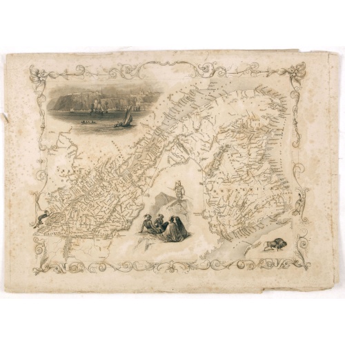
East Canada and New Brunswick.
This is John Tallis’ map of East Canada or what is now Quebec and New Brunswick. Includes Montreal, Quebec City, and the St. Lawrence River valley. Features five vignettes which include American Indian warriors and a spectacular view of Quebec City. The whole is surrounded by a decorative vine motif border. The vignettes for this map were drawn by H. Warren and engraved by J. B. Allen. The map itself is the work of John Rapkin. The Illustrations after a design by H. Warren and engraved by J Ra...
$75
Maker : TALLIS, J.
Place : London
Date : 1851
Amérique Méridionale.
Map of South America.Lovely map from one of the last decorative atlases of the nineteenth century.The rather simple map is framed by horses, Indians, jaguars, tapirs, and mining, as well as personifications of the rivers Amazon and La Plata at the top of the map. Victor Levasseur's "Atlas National Illustré" and "Atlas Universel Illustré" are among the last great decorative atlases published. This map comes from the Atlas National Illustré.
$90
Maker : LEVASSEUR, V.
Place : Paris, A. Combette
Date : 1852

A general chart of the South Atlantic Ocean Drawn by J.W.Norie hydrographer. Revised & Corrected 1854.
A 2-sheet chart of the South Atlantic Ocean, showing the coast of South America from the mouth of the Amazon to Quito in Peru. The right hand part showing Africa's coast at Angola. Scale: circa 1:8,000,000. Chart of the South Atlantic, in two sheets. Two insets, Port of Ascension and Anchorage off N.W. side of St. Helena.The chart is published for the first time in 1833, according to a date lower part map. This is A Revised & corrected edition by J.W. Norie in 1854
$600
Maker : NORIE, J.W.
Place : London
Date : 1854